
Arabic لفتا Also spelled Lefta Palestine grid 168/133 Date of depopulation January 1948 | Name meaning Lifta, personal name Area 8,743 dunams8.7 km² | |
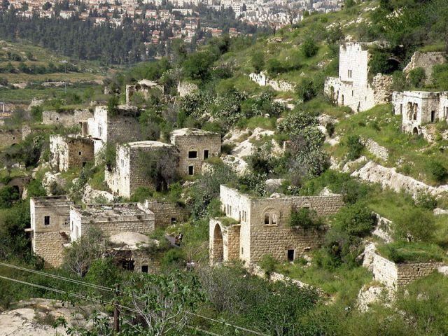 | ||
Lifta (Arabic: لفتا; Hebrew: מי נפתוח Mei Neftoach, lit. spring of the corridor) was a Palestinian Arab village on the outskirts of Jerusalem. The population was driven out during the Arab-Jewish hostilities of 1947/48 and the efforts to relieve the Siege of Jerusalem (1948). Mainly intact, it is located on the spot of the Tanachic village "Nephtoah", on a hillside between the western entrance to Jerusalem and the Romema neighbourhood. In 2012, plans to rebuild the village as an upscale neighborhood were rejected by the Jerusalem District Court.
Contents
Map of Lifta, Israel
Antiquity
The site was populated since ancient times; "Nephtoah" (Hebrew: נפתח) is mentioned in the Hebrew Bible as the border between the Israelite tribes of Judah and Benjamin. It was the northernmost demarcation point of the territory of the Tribe of Judah. The Romans and Byzantines called it Nephtho, and the Crusaders referred to it as Clepsta. The remains of a court-yard home from the Crusader period remains in the centre of the village.
Ottoman era
In 1596, Lifta was a village in the Ottoman Empire, nahiya (subdistrict) of Jerusalem under the liwa' (district) of Jerusalem, and it had a population of 396. It paid taxes on wheat, barley, olives, fruit orchards and vineyards.
In 1834, a battle took place here, during the revolt of that year. The Egyptian Ibrahim Pasha and his army fought and defeated local rebels, led by Shaykh Qasim al-Ahmad, a prominent local ruler. However, the Qasim al-Ahmad family remained powerful and ruled the region southwest of Nablus from their fortified villages of Deir Istiya and Bayt Wazan some 40 kilometers (25 mi) due north of Lifta.
In 1863 Victor Guérin described Lifta as being surrounded by gardens of lemon-trees, oranges, figs, pomegranates, alms and apricots. An Ottoman village list of about 1870 indicated 117 houses and a population of 395, though the population count included men only. The Palestine Exploration Fund's Survey of Western Palestine in 1883 described it as a village on the side of a steep hill, with a spring and rock-cut tombs to the south.
British Mandate era
In 1917, Lifta surrendered to the British forces with white flags and, as a symbolic gesture, the keys to the village.
In the 1922 census of Palestine, Lifta had a population 1,451, all Muslims, increasing in the 1931 census (when Lifta was counted with "Shneller's Quarter"), to 1,893; 1,844 Muslims, 35 Jews and 14 Christians, in a total of 410 houses.
During the 1929 Palestine riots inhabitants of the village actively participated in the robberies and attacks on nearby Jewish communities.
In 1945 the population of Lifta was 2,250; 2,230 Muslims and 20 Christians, and the total land area was 8,743 dunams, according to an official land and population survey. 3,248 dunams were for cereals, while 324 dunams were built-up (urban) land.
The village had a mosque, a shrine for Shaykh Badr (a local sage), two coffee houses, a social club, and a few shops. It also had an elementary school, one for boys and one for girls. The farmers of Lifta marketed their produce in Jerusalem markets and took advantage of the city's services.
In 1947, the Haganah shot a Lifta resident who informed Arab forces about the departure of Jewish convoys to Tel Aviv.
Israeli rule
In the 1948 war, one of the goals of the Haganah was securing the western exit of the city. Towards this end, Arabs fled from villages at the entrance to Jerusalem, among them from Lifta. According to historian 'Arif al-'Arif, a coffeehouse in Lifta was attacked by members of the Lehi, killing six people and wounding seven others. After the attack, most of the inhabitants fled, but the village remained largely intact. Some 55 original stone houses are still standing but the village has never been repopulated.
In 2011, plans were announced to demolish the village and build a luxury development consisting of 212 luxury housing units and a hotel. Former residents brought a legal petition to preserve the village as a historic site. Lifta is the last remaining Arab village that was depopulated to have not been either completely destroyed or re-inhabited. By 2011, three books about the Palestinian village history had been published.
Culture
Lifta was among the wealthiest communities in the Jerusalem area, and the women were known for their fine embroidery Thob Ghabani bridal dresses were sewn in Lifta. They were made of ghabani, a natural cotton covered with gold color silk floral embroidery produced in Aleppo, and were narrower than other dresses. The sleeves were also more tapered. The sides, sleeves and chest panel of the dress were adorned with silk insets. The dresses were ordered by brides in Bethlehem. The married women of Lifta wore a distinctive conical shaṭweh head-dress [1] that was also worn in Bethlehem, Ayn Karim, Beit Jala and Beit Sahour.