
 | ||
The Libyan Coastal Highway (Arabic: الطريق الساحلي الليبي) is a highway that is the only major road that runs along the entire east-west length of the Libyan Mediterranean coastline. It is a section in the Cairo–Dakar Highway #1 in the Trans-African Highway system of the African Union, Arab Maghreb Union and others.
Contents
Map of Coastal Hwy, Libya
Built under the rule of the Italian dictator Benito Mussolini in colonial Italian Libya in the 1930s, it was named Via Balbia' (or Litoranea Balbo) in honour of governor-general Italo Balbo, but renamed to "Libyan Coastal Highway" after independence and enlarged.
In the 2011 Libyan civil war the highway was a strategic and symbolic element, as the main route through the contested coastal region between Sirte and Benghazi.
Italian Libya
In March 1937, Italian dictator Benito Mussolini made a state visit to Italian Libya to open this new military and civilian highway, built by governor-general Italo Balbo. When Balbo died in 1940 in a plane crash, the Italian government named the 1822 kilometer road in his honour.
Italians constructed also a minor road parallel to the coastal one starting from Marj through Marawa, to Lamluda, and it is 143 km (89 mi) long.
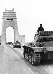
Near the middle of the road, the border of Italian Tripolitania and Italian Cyrenaica was marked by a Marble Arch, named Arch of Fileni. It was created by the Italian architect Florestano Di Fausto. There was an inscription at the top of the arch which read: Alme Sol, possis nihil urbe Roma visere maius (Latin for "Oh kind Sun, may you never look upon a city greater than Rome"). The "Arch of Fileni" was demolished in 1970 by the new coup d'état revolutionary regime of Muammar Gaddafi.
World War II
The highway was fully paved. However, in World War II, during the Western Desert Campaign of the Allies North African Campaign, the road was heavily used in fighting the Axis forces, and remained damaged for decades.
Independent Libya
The road was renamed Libyan Coastal Highway after the country gained independence and was improved with enlargements. It was fully repaved in 1967. According to Hussein Maziq, prime minister of Libya (1965–1967) under King Idris, there had been plans to make this road a dual carriageway road. Two parts were built: the Sabratha—Tripoli—Misrata section; and the Ajdabiya—Benghazi—Taucheira section. The entire construction did not occur because of the coup d'état political change by Muammar Gaddafi on 1 September 1969.
Before the 2011 Libyan civil war, the General People's Committee of Libya had issued an order for the Ras Ajdir—Sabratha section to be a dual carriageway road.
It's to be noted that some other roads in northern Cyrenaica are more Coastal, or closer to the coast, than the coastal highway itself, like Tolmeita-Tauchira road, and Derna-Susa road.
2011 civil war
In the 2011 Libyan civil war the highway was an active component for combat movement and skirmishes, and when a section's access and transit is under control - a strategic and symbolic element.
Junctions
The highway has become a junction for new southbound roads into the Fezzan region and Sahara, and new east-west shortcut highways in Cyrenaica and Tripolitania. They include: