
Country Philippines District 2nd district Barangays Area 342.8 km² Population 100,002 (2010) | Region Bicol (Region V) Founded April 3, 1574 Time zone PST (UTC+8) Local time Friday 11:09 AM Province Camarines Sur | |
 | ||
Weather 28°C, Wind NE at 19 km/h, 65% Humidity Neighborhoods Bahao, Bahay, Libod I, Binobon, Taban-Fundado | ||
Poro beach bahao libmanan camarines sur
Libmanan is a first class municipality in the province of Camarines Sur, Philippines. According to the 2010 census, it has a population of 100,002.
Contents
- Poro beach bahao libmanan camarines sur
- Map of Libmanan Camarines Sur Philippines
- History
- Geography
- Barangays
- Religion
- Economy
- Education
- References
Map of Libmanan, Camarines Sur, Philippines
History
Libmanan was a bario of Quipayo in 1580 with the name of "Piglabanan". Records from a historian revealed that the municipality was named Libmanan on September 15, 1574. Missionaries started working in Libmanan in 1589 and the area's church was dedicated to St. James the Apostle. Several local stories hint as to the origin of the town’s name. One was that “ligmanan” means "a place surrounded with waterways". Another was Libangan since visitors forgot their former homes because they were said to be “na libang” or "enjoying themselves" - Libangan can also translate to "place of enjoyment". Another version was associated with the conditions during years of moro raids where area was called “Linabanan”, a battle ground. In the Old Spanish Records, Fray Pasqual de la Cruz, writes the name of the town as "Libñanan" the Spanish way of pronouncing the word. The same Record also show that in 1823, Fray Francisco Valverde wrote it as "Libmanan" because it was easier to write and pronounce as well.
German ethnographer Fedor Jagor described visiting Libmanan in his 1875 work "Travels in the Philippines", wherin he visited the local parish priest and learned from him about an ancient human settlement that had been dug up in 1851 during road construction in the Poro area of the southwest close near the Tres Marias islands: the excavation consisted of "numerous remains of the early inhabitants—skulls, ribs, bones of men and animals, a child’s thighbone inserted in a spiral of brass wire, several stags’ horns, beautifully-formed dishes and vessels, some of them painted, probably of Chinese origin; striped bracelets, of a soft, gypseous, copper-red rock, gleaming as if they were varnished; small copper knives, but no iron utensils; and several broad flat stones bored through the middle; besides a wedge of petrified wood, embedded in a cleft branch of a tree."
During the occupation of their country by the United States, the Philippine Legislature greatly expanded the network of railroads throughout the island of Luzon, and a railway headed to the city of Legazpi, Albay and Naga, Camarines Sur was built through Libmanan to provide direct access to those cities. This railway was damaged severely during World War II, but partially restored using American funds thereafter, providing transportation service down the Bicol Peninsula off and on until ending in 2012 despite plans to rehabilitate the route.
Even during the time of the Spaniards, the town of Libmanan was already considered the "rice basket" of the province. This generous production of rice is attributed to the fertile soil and the town's abundant water supply. In 1991 the area's irrigation canals (shared with its northern neighbor Cabusao, Camarines Sur) were sufficient to water 2996 hectares of land during the dry season.
Geography
Libmanan is an extremely large municipality, one of the biggest in Camarines Sur. It stretched across nearly the whole width of the Bicol peninsula, from where it borders Cabusao Municipality on the San Miguel Bay all the way out to the Ragay Gulf, including three islands known locally as the 'tres Marias', including one island known as 'puro island'. The main town, or 'poblacion', is located along the Libmanan River on the lowland alluvial plain adjacent to Cabusao.
Heading to the southern coast from the poblacion the municipality becomes hilly. In this hilly region between the poblacion and the highway lies the Libmanan Caves National Park. Continuing on towards the coast from the hills, the municipality becomes truly mountainous beginning in Barangay Malinao beyond the Pan-Philippine Highway, where the "Boro-Boro Spring Resort" is located; a series of waterfalls that are a locally popular swimming destination. Beyond Malinao the upland region features the mountain 'Tancong Vaca' - in the local dialect meaning 'the cow's hump' - which is a local landmark visible from most locations on the Pan-Philippine Highway in western Camarines Sur and was a base of operations for local guerrillas fighting the Japanese during World War II. Up to the present day, the area around Tancong Vaca has remained an area of conflict between anti-government insurgents and the Philippine National Police.
The municipality's rural barangays lie behind Mount Tancong Vaca, and mostly lack access to paved roads, of which there is only one which terminates in the fishing village of Barangay Bahao, within sight of the tres Marias.
Barangays
Libmanan is politically subdivided into 75 barangays; five of which are located in the coastal areas and the remaining 70 barangays are distributed in the low land and upland portions of the municipality. Its town center, poblacion or centro, is 7.7 kilometres (4.8 mi) away from the National Highway. The road leading to Poblacion and other major baranggays is marked by a memorial for the Ten Outstanding Young Men trophy awarded to a past mayor and local hero, Jose Bulaong.
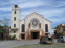
Religion
The religious needs of its people and those of neighboring towns prompted the erection of the Prelature of Libmanan in 1990 and installation the first bishop, Msgr. Prospero N. Arellano . On 25 March 2009 Pope Benedict XVI elevated the prelature to become a diocese with Bishop Jose Rojas Rojas becoming its first bishop.
The Catholic Bishops' Conference of the Philippines lists the following Catholic church parishes of Libmanan:
Economy
Libmanan, one of the largest and most populous municipality in the province, benefits from the transportation being offered by the Libmanan River, the railroad and the national highway. Though rail service through Libmanan no longer connects directly to Manila there are still commuter trips available bringing passengers to nearby Naga, Camarines Sur and the route that was reopened in 2015 bringing them all the way to Legazpi, Albay.
Generally, Libmanan soil is adapted for growing different agricultural products. Portions are also adopted to pottery-the making of which has been a local industry for centuries. Libmanan has been the “rice-basket” not only of the province but of Southern Luzon-even during the Spanish regime. In spite of problems encountered by rice farmers, Libmanan maintains its status of being the rice granary of the province.
Education
The Department of Education (Philippines) lists the following schools for Libmanan: