
Area 84.98 km² | Surface area 21,000 acres (85 km) Surface elevation 155 m | |
 | ||
2015 flw tv lewis smith lake
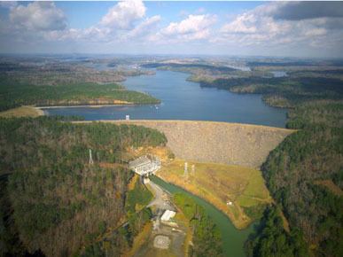
Lewis Smith Lake is a reservoir in north Alabama. Located on the Sipsey Fork of the Black Warrior River, the lake covers over 21,000 acres (85 km2) in Cullman, Walker, and Winston counties. The maximum depth at the dam is 264 feet. The three-fingered lake has over 500 miles (800 km) of shoreline, and at full pool has a level of 510 feet (160 m).
Contents
- 2015 flw tv lewis smith lake
- Map of Lewis Smith Lake Alabama USA
- Flw circuit breaker s03e02 lewis smith lake
- References
Map of Lewis Smith Lake, Alabama, USA
The lake was created by Alabama Power with the construction of the Lewis Smith Dam. One of the largest earthen dams in the eastern United States, it stretches 2,200 feet (670 m) in length and reaches a maximum height of 300 feet (91 m). Construction began on November 25, 1957, and the dam entered service on September 5, 1961. The name honors Lewis Martin Smith, president of Alabama Power from 1952 to 1957.
Nearby towns include Bremen, Crane Hill and Dodge City in Cullman County; Curry and Jasper in Walker County; and Addison, Arley, Houston, and Double Springs in Winston County.
The most popular tourist attraction on Smith lake is the Indian head cliff jump. It's 70 feet ( 21m ) and is located on the south shoreline of Smith lake. It's considered the most dangerous cliff jump located on Smith lake. There have already been two deaths reported where the victims just didn't surface. The bodies were later found.