
Demonym(s) Lettesi Postal code 65020 Dialling code 085 | Elevation 370 m (1,210 ft) Area 15 km² Local time Thursday 11:03 AM Patron saint Saint Nicholas | |
 | ||
Frazioni Canale Calvario, Lavino Chiuse Weather 13°C, Wind SW at 8 km/h, 52% Humidity | ||
Speciale lettomanoppello 11 2013
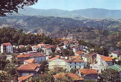
Lettomanoppello is a town and comune in Pescara province, in Abruzzo, central Italy. In Roman times the area was known for its asphalt mines and later for a white stone that could be carved.
Contents
- Speciale lettomanoppello 11 2013
- Map of 65020 Lettomanoppello Province of Pescara Italy
- The winner is lettomanoppello
- Geography
- History
- References
Map of 65020 Lettomanoppello Province of Pescara, Italy
The winner is lettomanoppello
Geography
The town is situated near the Majella National Park, about 30 minutes away from the city of Pescara. The mountainous region offers sightseeing in the wilderness or on its highest peaks. The elevation stretches from about 300 metres (980 ft) above sea level and a road leads right up the top, at 2,100 metres (6,900 ft). During winter it becomes a spot for skiing and winter sports in the mountains.
The town is commonly called "Lu Lette" and the mountain passages are commonly called "Passe Lanciano" by locals.
History
The history of the current town dates back to the 11th century but was certainly occupied earlier by Romans to excavate asphalt. It is also quarried for its white stone and marble.