
Population 7,956 (2006 census) | Postcode(s) 6076 Postal code 6076 | |
 | ||
Location 21 km (13 mi) from Perth, Western Australia | ||
Lesmurdie is a suburb of Perth, Western Australia, located within the Shire of Kalamunda.
Map of Lesmurdie WA 6076, Australia
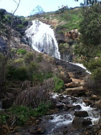
It is viewed as being a rival suburb to the neighbouring suburb of Kalamunda directly to the north. The main access to the suburb from the Swan Coastal Plain is via Welshpool Road, that snakes its way up the side of the Darling Scarp from the suburb of Wattle Grove. Lesmurdie can also be accessed from Kalamunda, Walliston, Carmel and Bickley, primarily through Canning Road.
The main road is Lesmurdie Road, which starts from the south as a T-junction with Welshpool Road and finishes at a roundabout intersection with Canning Road and Lesmurdie Road East. Important secondary roads include Falls Road, Grove Road, Glyde Road, Gladys Road, Sanderson Road and Pomeroy Road. The shopping centres in the area are the Lesmurdie Village on Sanderson Road and the Lesmurdie Road Shopping Centre on the corner of Rooth Rd and Lesmurdie Rd.
Lesmurdie has three high schools within its boundaries, the government operated Lesmurdie Senior High School as well as the privately operated Mazenod College for boys and St Brigid's College for girls. There are two government primary schools in Lesmurdie, Lesmurdie Primary School and Falls Road Primary School as well as a privately operated primary school at St Brigid's.