
Canton Morez Population (2013) 3,137 Local time Thursday 12:58 AM | Intercommunality Station des Rousses Area 38 km² | |
 | ||
Region Bourgogne-Franche-Comté Weather 6°C, Wind E at 11 km/h, 52% Humidity Points of interest Domaine skiable de la Station, Lac des Rousses, Musée du Ski et de la Tradition | ||
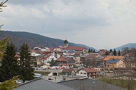
Les Rousses is a commune in the Canton of Morez of Jura department in the Bourgogne-Franche-Comté region in eastern France, on the Swiss border.
Contents
Map of Les Rousses, France
The Lac des Rousses is located northeast of the village of Les Rousses beside the road to the village of Bois d'Amont. The Lac de Lamoura is located southwest of the village of Les Rousses beside the road to the village of Lamoura. Other places include the village of Prémanon, and La Cure, the transit point across the Swiss border towards Saint-Cergue.
Les rousses top of the skilift timelapse
Tourism
Les Rousses includes part of the Upper Jura Natural Park and Fort des Rousses, an historical fortress that, until 1997, was used as a commando training site. The fortress includes an underground labyrinth used in training, that is open to the public.
Les Rousses has an extensive ski area, especially for cross-country skiing. Many villages have their own runs using a common lift pass.