
Population 769 (1999) | Area 5.45 km² Local time Wednesday 10:47 PM | |
 | ||
Weather 6°C, Wind SW at 3 km/h, 86% Humidity | ||
Les Ayvelles is a French commune in the Ardennes department in the Grand Est region of northern France.
Contents
- Map of 08000 Les Ayvelles France
- Geography
- Administration
- Demography
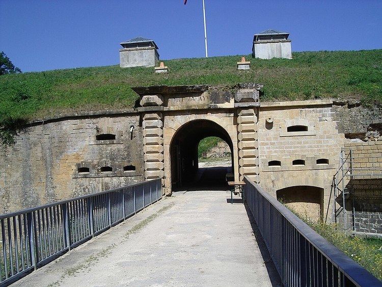
- Civil heritage
- Religious heritage
- References
Map of 08000 Les Ayvelles, France
The inhabitants of the commune are known both as Ayvelliens or Ayvelliennes as well as Ayvellois or Ayvelloises.
Geography
Les Ayvelles is located just 5 km south-east of Charleville-Mézières. Access to the commune is by road D764 from Villers-Semeuse in the north which passes through the centre of the commune and the village and continues to Flize in the south. The commune has large reservoirs in the east and a forest in the west (the Bois des Ayvelles) with the rest of the commune farmland.
The Meuse river forms the eastern border of the commune as it flows north to Belgium. The Ruisseau du Pierge rises in the west of the commune and flows east to join the Meuse.
Administration
List of Successive Mayors
(Not all data is known)
Demography
In 2010 the commune had 927 inhabitants. The evolution of the number of inhabitants is known from the population censuses conducted in the commune since 1793. From the 21st century, a census of communes with fewer than 10,000 inhabitants is held every five years, unlike larger communes that have a sample survey every year.
Sources : Ldh/EHESS/Cassini until 1962, INSEE database from 1968 (population without double counting and municipal population from 2006)
Civil heritage
Religious heritage
The Parish Church of Saint Rémi contains several items that are registered as historical objects: