
 | ||
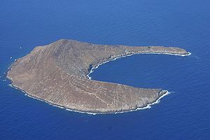
Lehua Island is a small, crescent-shaped island in the Hawaiian islands, only 0.7 miles (1.1 km) north of Niʻihau, due west of Kauai. The uninhabited, 284-acre (1.15 km2) barren island is a tuff cone which is part of the extinct Niʻihau volcano.
Map of Lehua, Hawaii 96769, USA
Lehua was one of the first five islands sighted by Captain James Cook in 1778 which he spelled as "Oreehoua".
Lehua Island is a Hawaii State Wildlife Sanctuary. As a restricted sanctuary, all activities are prohibited on the island without a permit. Public access to the island is restricted to areas below the high tide water mark. Lehua provides habitat for at least 16 species of seabirds, as well as non-native Pacific rats. A population of European rabbits had lived on the island for many years but were removed in 2005.
When weather and wave conditions permit crossings from Kauai, Lehua is a noted destination for snorkeling and scuba diving. It is also well known for an unusual geological formation dubbed "the keyhole". Located in one of the crescent's narrow arms, this is a tall, thin notch cut from one side, all the way through to the other side of the arm.
The United States Coast Guard maintains Lehua Rock Light (a lighthouse) on Kaunuakalā, at 704 feet (215 m) the highest point of the island.