
Highest elevation 1,300 m (4,300 ft) Time zone EET (UTC+2) Local time Wednesday 12:47 AM Area code 2721 | Districts 19 Lowest elevation 0 m (0 ft) Vehicle registration KM Postal code 24022 | |
 | ||
Weather 10°C, Wind N at 8 km/h, 73% Humidity | ||
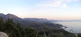
Lefktro (Greek: Λεύκτρο) is a village and a former municipality in Messenia, Peloponnese, Greece. Since the 2011 local government reform it is part of the municipality West Mani, of which it is a municipal unit. The municipal unit has an area of 222.981 km2. Its population is 4,699 (2011). The seat of the municipality was in Kardamyli. The village Lefktro is located above the larger village of Stoupa. Also known as Choriadaki (little town), it contains some restored Mani towers and a few newer houses, virtually all built in the traditional style, of local stone. A ten-minute walk to the sea and Stoupa's beach, it is on the slopes leading up to the Taygetos mountains.
Map of Lefktro 240 24, Greece
References
Lefktro Wikipedia(Text) CC BY-SA