
Primary Dolostone | Province Alberta Overlies Beaverhill Lake Group | |
 | ||
Thickness up to 300 metres (980 ft) | ||
The Leduc Formation is a stratigraphic unit of Late Devonian (Frasnian) age in the Western Canada Sedimentary Basin. It takes its name from the city of Leduc, and it was formally described from the B.A. Pyrz No. 1 well in central Alberta, between the depths of 1,623.7 m (5,327 ft) and 1,807.5 m (5,930 ft), by Imperial Oil Limited in 1950. Supplementary information came from a complete section of the formation that was cored in Imperial Oil's Leduc No. 530 well between 1,633 m (5,358 ft) and 1,863 m (6,112 ft).
Contents
- LithologyEdit
- Oil and gas productionEdit
- Distribution and thicknessEdit
- Relationship to other unitsEdit
- References
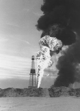
The Leduc Formation is a major producer of oil and gas in central Alberta, and the drilling of the highly successful Leduc No. 1 well in 1947 ushered in a new era in the Western Canadian petroleum industry.
LithologyEdit
The Leduc Formation consists of fossil reefs that are highly porous, which makes them excellent reservoirs for oil and gas. They were deposited as limestone and mudstone in shallow water reef environments. Stromatoporoids were the primary reef-building organisms, and rock-types range from skeletal mudstones and floatstones to finer grained muddy packstones and wackestones. Many, but not all, of the reefs were later subjected to dolomitization during diagenesis, which increased their porosity, and they now consist of dolostone rather than limestone.
Oil and gas productionEdit
The Leduc Formation is a major producer of oil and gas in central Alberta. The Leduc No. 1 well which was drilled in 1947 produced 50 thousand cubic metres (more than 300 thousand barrels) of oil and marked the beginning of the post-war Albertan oil boom. The Strachan and Ricinus West gas fields, discovered in 1967 and 1969, also produce from Late Devonian Leduc-age reefs.
Distribution and thicknessEdit
Leduc Formation occurs as discrete, discontinuous reef "buildups" in a line following the Woodbend shelf margin from Drumheller in central Alberta to the Peace River Arch area in northern Alberta. The formation is absent in inter-reef areas, and buildups can reach from 180 meters (590 ft) to 300 meters (980 ft) in thickness.
Relationship to other unitsEdit
In central Alberta the Leduc Formation conformably overlies the platform limestones and dolostones of the Cooking Lake and Beaverhill Lake Formations. In northern Alberta near the Peace River Arch it rests on older red beds or on the Granite Wash. The Leduc reefs are surrounded by shales of the Duvernay and Ireton Formations and the Woodbend Group that were deposited in non-reefal, open marine environments.
The Leduc reefs are the same ages as, but not contiguous with, the reefs of the Cairn Formation which are located farther west. Because the Leduc reefs are nowhere exposed at surface, the extensive outcrops of the Cairn reefs in the Canadian Rockies have been studied to increase the understanding of the Leduc reefs.