Harman Patil (Editor)

Le Val Saint Père

Updated on
Edit
Like
Comment
Share on FacebookTweet on TwitterShare on LinkedInShare on Reddit
Country
  
France

Department
  
Manche

Intercommunality
  
Avranches

Area
  
11.1 km²

Arrondissement
  
Avranches

Region
  
Normandy

Canton
  
Avranches

Population (2009)
  
1,858

Local time
  
Tuesday 7:44 AM

Le Val-Saint-Père httpsuploadwikimediaorgwikipediacommonsthu

Weather
  
7°C, Wind SW at 6 km/h, 96% Humidity

Le Val-Saint-Père is a commune in the Manche department in Normandy in northwestern France.

Contents

Map of 50300 Le Val-Saint-P%C3%A8re, France

Geography

Le Val-Saint-Père is situated on the Saint-Michel bay, and is near Avranches, Saint-Martin-des-Champs, Saint-Loup, Saint-Quentin-sur-le-Homme and Pontaubault.

Demographics

The commune's population has held remarkably steady during the preceding two centuries, only showing a marked increase (100% growth) in the last 30 years:
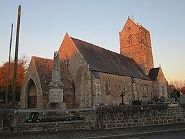
  • 1793 - 1112
  • 1800 - 1136
  • 1806 - 1037
  • 1821 - 1025
  • 1831 - 1045
  • 1836 - 992
  • 1841 - 1073
  • 1846 - 1238
  • 1851 - 1241
  • 1856 - 1167
  • 1861 - 1147
  • 1866 - 1158
  • 1872 - 1092
  • 1876 - 1158
  • 1881 - 1183
  • 1886 - 1118
  • 1891 - 1092
  • 1896 - 1105
  • 1901 - 1000
  • 1906 - 1002
  • 1911 - 944
  • 1921 - 833
  • 1926 - 842
  • 1931 - 903
  • 1936 - 963
  • 1946 - 956
  • 1954 - 1031
  • 1962 - 916
  • 1968 - 857
  • 1975 - 1340
  • 1982 - 1594
  • 1990 - 1609
  • 1999 - 1574
  • 2009 - 1858
  • Points of interest

  • The Avranches airport is situated in Val-Saint-Père, in Bouillé.
  • Le Gué de l’Épine affords a view of Mont Saint-Michel.
  • References

    Le Val-Saint-Père Wikipedia