
Population (1999) 84 Local time Tuesday 7:24 AM | Region Occitanie Area 25.18 km² | |
 | ||
Weather 8°C, Wind NW at 19 km/h, 69% Humidity | ||
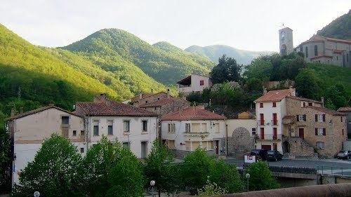
Le Tech (Catalan: El Tec) is a commune in the Pyrénées-Orientales department in southern France. It is part of the historical Vallespir comarca.
Contents
- Map of 66230 Le Tech France
- Localisation
- Land relief
- Hydrography
- Toponymy
- History
- Population
- Sites of interest
- References
Map of 66230 Le Tech, France
Population Over Time
Localisation
Le Tech is located east of Prats-de-Mollo-la-Preste, in the canton of Prats-de-Mollo-la-Preste and in the arrondissement of Céret..
Land relief
Elevation ranges from 420 to 2721 meters.
Hydrography
The territory of Le Tech is shaped by the valley of the river Coumelade and the village itself is located at the confluence of the Coumelade and the river Tech.
Toponymy
Le Tech takes its name from the Tech river which runs through the village.
History
The commune of Le Tech was created on March 19th, 1862, by a piece of territory being separated from Prats-de-Mollo.
Population
Sources : Ldh/EHESS/Cassini until 1962, INSEE database from 1968 (population without double counting and municipal population from 2006) ·
Population Over Time