
Location Caribbean sea Total islands 9 Overseas department Guadeloupe | Archipelago Îles des Saintes Major islands Terre-de-Bas Island Canton les Saintes | |
 | ||
Island groups Antilles, Lesser Antilles, Îles des Saintes, Leeward Islands | ||
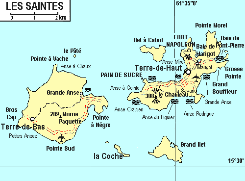
Le Pâté is an island in shape of high plateau in the archipelago of Îles des Saintes including the commune (municipality) of Terre-de-Bas. It is located at 900 m (0.56 mi) of the northern headland of Terre-de-Bas Island, called Pointe à Vache. It opens the Pain de Sucre Passage (Sugar loaf) which is the main shipping lane to access to the Bay of les Saintes by the North.
Contents
Map of Le pate, Guadeloupe
The ascent of this island is very difficult, the swell and the Ocean currents are very violent and the winds very changeable.
Scuba diving
Not far away of the islands, there is an exceptional dive site called sec Pâté. Sec Pâté, is classified among the hundreds most beautiful sites of the worlds and stays one of the wealth of the heritage of Îles des Saintes. Sec Pâté, is a submarine mountain, which the base belongs at less 300 m (980 ft) deep and the top at less 15 m (49 ft) below sea level. The maritime conditions make this dive difficult and the level 2 is required. The place abounds in a large quantity of diversified fishes, sea turtles, sea fans, corals, gorgonians, lobsters and shellfishes which appropriate the marine domain, around three rock peaks which form the top of the mountain.