
Country France Department Puy-de-Dôme Time zone CET (UTC+1) Area 35.87 km² Local time Tuesday 5:47 AM | Region Auvergne-Rhône-Alpes Canton Rochefort-Montagne INSEE/Postal code 63236 /63240 Population 1,682 (1999) Arrondissement Clermont-Ferrand | |
 | ||
Weather 4°C, Wind E at 10 km/h, 76% Humidity Points of interest Puy de Sancy, Lac de Guéry, Funiculaire du Capucin, La Grande Cascade, Cascade du Queureuilh | ||
Le Mont-Dore (Mont Dòr in Auvergnat), formerly called Mont-Dore-les-Bains, is a commune in the Puy-de-Dôme department in Auvergne in central France.
Contents
Map of 63240 Le Mont-Dore, France
Geography
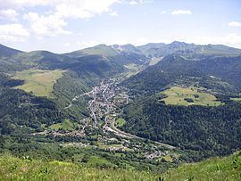
Le Mont-Dore is located in the Massif Central, on the right bank of the Dordogne River not far from its source, and 50 km (31 mi) by road S.W. of Clermont-Ferrand. The Monts Dore close the valley towards the south.
Thermal springs
The thermal springs of Le Mont-Dore, now numbering twelve, were known to the Romans. Bicarbonate of soda, iron and arsenic are the principal ingredients of the waters, which are used both for drinking and bathing. Hot baths are characteristic of the treatment; they are believed to be efficacious for tuberculosis, bronchitis, asthma, and nervous and rheumatic paralysis. Due to the elevation and exposure of the valley, the climate of Le Mont-Dore is relatively severe, and the season only lasts from 15 June to 15 September. The bath-house was rebuilt in 1891-1894.
Ski resort
Le Mont-Dore is a ski resort with runs on the slopes of the Puy de Sancy and the Puy Ferrand. 30 runs account for 42 km of downhill skiing, served by a number of lifts of different types. There are also 25 km of cross-country trails.
Sights
In the town park, along the Dordogne, relics of the old Roman baths have been collected. The surrounding country, with its fir woods, pastures, waterfalls and mountains, is very attractive. To the south is the Puy de Sancy (1886 m or 6189 ft), the loftiest peak of central France.