
Time zone WET (UTC+0) Elevation 0 cm | Irish Grid Reference O162714 Local time Tuesday 12:42 AM | |
 | ||
Weather 12°C, Wind SW at 27 km/h, 79% Humidity | ||
Laytown (Irish: An Inse, meaning "the holm") is a village in County Meath, Ireland, located on the R150 regional road and overlooking the Irish Sea. Historically it was called Ninch, after the townland it occupies. Together with the neighbouring villages of Mornington and Bettystown it comprises the census town of Laytown-Bettystown-Mornington with a combined population of 10,889 at the 2011 Census, which is part of the wider area collectively known as East Meath.
Contents
- Map of Laytown Co Meath Ireland
- History
- Archaeological finds
- Geography
- Buildings of note
- Education
- Transport communications
- Amenities
- Laytown on film
- Laytown today
- Laytown races
- References
Map of Laytown, Co. Meath, Ireland
History
The surrounding area is known to have been settled for around 1500 years; recent excavations have revealed settlement at Laytown since at least the 6th century AD.
Archaeological finds
Geography
Laytown is 50 km (30 mi) north of the nation's capital, Dublin. Laytown and neighbouring village, Bettystown, sit on one of Ireland's most scenic beachfronts. The beach stretches from Mornington at the River Boyne, which borders County Louth to Gormanston at the River Delvin, which borders County Dublin.
Laytown sits on the mouth of the River Nanny, a tidal estuary where mullet, trout, eels, gobies and flounder can be caught - but no salmon. According to local folklore, Saint Patrick banished all the salmon from the river. By an old schoolhouse overlooking the river there is a spring known as St Patrick's Well, though the access path to it is overgrown.
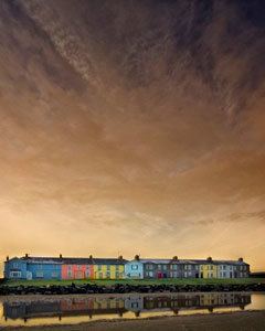
Buildings of note
Many of Laytown's larger buildings, including the train station master's house and the large terrace homes facing onto the beach were built in the mid-nineteenth century. [3] The architecture of the Church of the Sacred Heart is of particular note: the facade is retained from the original nineteenth century, but the main building is a 1970s circular-plan single room with a large window overlooking the Irish Sea. On the hill behind the window is a twenty-foot wooden cross. [4]
Education
There are two primary schools in Laytown/Bettystown which follow a Catholic ethos. They are Scoil Oilibhear Naofa Junior School and Scoil an Spioraid Naomh Senior School. Scoil Oilibhear Naofa is a recently built state-of-the-art school and the Department of Education has plans for a complete redevelopment of Scoil an Spioraid Naomh.
There are also two multi-denominational schools outside the town that service East Meath and South Drogheda. They are Le Cheile Educate Together National School and Gaelscoil an Bhradain Feasa. These schools teach an ethical programme and a basic type of comparative religion. If parents want the children to have faith formation in any particular religion, they have to arrange that in after school classes.
A new secondary school (Colaiste na hInse) has been built in Laytown which services the East Meath area.
Transport & communications
The village has become well established as a commuter town for people working in Dublin on the line into Dublin Connolly station, and fuelled by the completion of the M1 motorway linking the north east of the country to the capital. The village is served by the Northern commuter train line linking Drogheda and Dundalk to Connolly station in Dublin. Laytown railway station opened on 25 May 1844 and was renamed as Laytown & Bettystown in 1913. An express coach service links Laytown, Bettystown and Sonairte with Parnell Street in Dublin. Bus Éireann route 190 provides several daily services to/from Drogheda via Bettystown and Mornington.
Amenities
The town has a garda station and a primary school called Scoil an Spioraid Naoimh . Coláiste na hInse in Laytown has been given the go ahead to go to tender for 1,000 pupils with a special needs unit. The village also consists of three pubs, two newsagents, a pharmacy, two take-aways and a railway station.
Sonairte: The National Ecology Centre is half a mile from the station on the Julianstown road (R150). [5]
Laytown on film
Both Irish and American movies (The Crying Game and Michael Collins) and television shows have been filmed all over Laytown, mostly on the beach. The Crying Game was filmed locally in the village of Laytown in 1991. A pictorial record 1987-1996 was completed by Pat Burns Photography and denotes events and culture in the area.
Laytown today
Laytown was once a tiny coastal village, but in the past decade, the town has seen both a huge population and economic boom. With the ever developing and growing city of Dublin, Laytown, along with other villages and towns all along the east coast, has recorded a population boom. This has brought problems with overcrowded schools. [6]
Laytown races
Since 1868 Laytown has hosted a single annual horse racing meeting on its beach - one of only a couple on sand (held on the beach) race meetings run under official rules of racing in Europe. The BBC have made it the subject of a documentary, titled Racing the Tide, and have included passages in their Coast and Countryfile programmes. The horses used to run along the beach, make a U-turn and run back. The onlookers used to stand just feet away from them to watch the racing, with no barriers in between. In 1994 a tragic accident occurred when one of the horses became spooked by a small river stream on the course and bolted into the crowd. This caused panic amongst some of the other horses too. One jockey was taken to hospital, several people in the crowd were injured, and perhaps most sad of all, three horses had to be put down because of the injuries they sustained. The races were abandoned for a few years and when they did restart, several safety measures had been put into practice. Barriers were constructed, the crowd were separated from the runners and now watch from a field next to the beach, the number of runners in each race was limited and the races were limited to much shorter distances with no turning round.