
Population 589 (2011) | Sovereign state United Kingdom Postcode district IP7 5 District Babergh | |
 | ||
Layham is a small village and a civil parish in southern Suffolk, England, situated between the town of Hadleigh and the neighbouring village of Raydon.
Contents
Map of Layham, Ipswich, UK
The civil parish contains the villages of Upper Layham and Lower Layham, separated by the River Brett. It is part of the Babergh district and it is currently represented by Tim Yeo M.P.
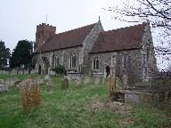
It has a church, St Andrews, and a public house, The Queen's Head, which are both situated in Lower Layham. More information on these and other aspects of Layham appear on the Parish Council's web site.
History
Layham is mentioned in the Little Domesday book.
"Æelfnoth held Layham from Harold TRE as a manor with three carucates of land. Then as now 4 villans and 7 bordars. Then five slaves now six. Then as now 2 ploughs in demesne and two ploughs belonging to the men. Eleven acres of meadow, one horse, fifteen head of cattle, fifteen pigs, 100 sheep and nineteen goats. Then it was worth seventy shillings now 100 shillings. It is half a league long and a half broad four and a half pennies in geld. St Edmund had the soke."