Elevation 683 m | Mountain range Ore Mountains | |
 | ||
Similar Adlerstein, Dittersdorfer Höhe, Hirtstein, Kahleberg, Pöhlberg | ||
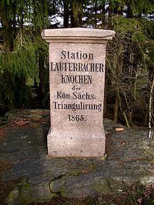
The Lauterbacher Knochen is a 683-metre (2,241 ft) high peak about one kilometre north of the village of Lauterbach in the municipality of Marienberg in the Ore Mountains. At the summit there is a historic station which was part of the Royal Saxon Triangulation Network.
Contents
Map of Lauterbacher Knochen, 09496 Marienberg, Germany
Location
Together with the Dreibrüderhöhe the ridge forms the watershed between the rivers Zschopau and Flöha on the borders of the Marienberg Plateau.
Views
Despite its modest height it offers a panoramic view. To the northwest the Waltersdorf Heights are visible. To the east is the mining town of Sayda and the Schwartenberg. To the south the Annahöhe, the Steinhübel, the Hirtstein and the Dreibrüderhöhe may be made out. To the southwest is the Pöhlberg, and on the horizon the Fichtelberg and Keilberg can be recognised. The Adlerstein is also nearby.
