
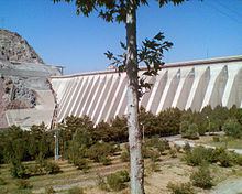
Official name سد لتیان Opening date 1967 Height 107 m (351 ft) Construction began 1963 | Purpose Water supply, power Impounds Jajrood River Opened 1967 Impound Jajrood River | |
 | ||
Similar Lar Dam, Amir Kabir Dam, Alborz, Sangan Waterfall, Burnik Cave | ||
Latyan Dam (Persian: سد لتيان, also Romanized as Sadd-e Latyān) is a buttress dam on the Jajrood River, located less than 25 km from Tehran in the south of city of Lavasan. It is one of the main sources of water for Tehran metropolitan region. It was constructed between 1963 and 1967. The first generator in the dam's 45 MW hydroelectric power station was commissioned on 17 March 1969, the second on 13 April 1987.
Contents
Map of Latyan Dam, Iran
GeologyEdit
Jajrood River basin is located in the southern part of central Alborz mountain range, the rocks of which date from the Palaeozoic era up to the Quaternary period, as below:
References
Latyan Dam Wikipedia(Text) CC BY-SA