
Founded May 14, 1888 Area 2,789 km² | Website latah.id.us Population 38,078 (2013) | |
 | ||
Rivers Paradise Creek, Kauder Creek, Potlatch River Points of interest University of Idaho Arboretu, McConnell Mansion Museum, Appaloosa Museum & Heritage, Skate Park, Virgil Phillips Farm Park | ||
Unicycling on the palouse trail latah county idaho july 12 2013
Latah County (pron. /ˈleɪtɑː/ LAY-tah) is a county located in the north central region of the U.S. state of Idaho. As of the 2010 census, the population was 37,244. The county seat and largest city is Moscow, the home of the University of Idaho, the state's flagship and land-grant university.
Contents
- Unicycling on the palouse trail latah county idaho july 12 2013
- Map of Latah County ID USA
- Mystery bugs swarming latah county idaho fall 2014
- Settlement
- Development of Cities
- County Boundary History
- Geography
- Adjacent counties
- Major highways
- National protected area
- 2000 census
- 2010 census
- Government and politics
- Flora and fauna
- Census designated place
- Ghost towns
- References
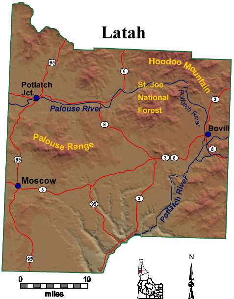
Map of Latah County, ID, USA
The county was created 129 years ago in 1888 and named for Latah Creek in its northwest corner. The name in the Nez Perce language means "the place of pine trees and pestle." The tribe found shade under the white pine trees for doing their work and stones suitable for use in pulverizing camas roots to process as one of their food staples.
Latah County comprises the Moscow, ID Micropolitan Statistical Area, which is included in the Pullman-Moscow, WA-ID Combined Statistical Area.
The county comprises the majority of the eastern portion of the Palouse, famous for its rolling hills and rich agriculture. Latah County is the only county in the U.S. established by an act of Congress; it was originally part of Nez Perce County, which was reluctant to lose its most populated area.
Mystery bugs swarming latah county idaho fall 2014
Settlement
Settlement of the Palouse County commenced in 1871. Development of population centers at Genesee and Moscow are the earliest followed by Juliaetta and Kendrick in the 1880s. The railroad's arrival in Moscow in 1885 led to its development as the primary population center of the county. The establishment of the University of Idaho at Moscow in 1889 also was significant in the city's continued growth. Settlement of Troy commenced in 1895 with Bovill being first settled by Lord Hugh Bovill in 1899. Construction of a railroad from Moscow to Bovill was completed in 1907 with the town of Deary developing in that year on the railroad. Potlatch was settled as a company town in 1905.
Development of Cities
Moscow first shows in the 1880 census with a population of 76. It was incorporated as a village in 1887. Genesee was established as a town in 1889. Julieatta, Kendrick, and Troy were established as towns by the 1900 Census, with each incorporating as a village prior to 1910. Bovill and Deary were incorporated as villages prior to 1920. Potlatch and Onaway remained unincorporated as late as 1960. They were returned at the 1950 Census as a single unincorporated area.
County Boundary History
The Idaho Territorial Legislature established the counties of Lah-Toh and Kootenai on December 22, 1864. Lah-Toh contained all of northern Idaho west of Shoshone County between the Clearwater River and 48° north latitude. Coeur d'Alene was named the county seat of Lah-Toh County. The legislature was well aware that settlement was lacking in the area to support a county government and established that the Governor could organize the county commission upon receipt of a petition from fifty residents. On January 9, 1867, the Fourth Idaho Legislature repealed the act creating the two counties, established the northern line of Nez Perce County to coincide with the present northern line of Latah County, and placed the remaining portion of Lah-Toh within the boundary of Kootenai County. Unaware of Lah-Toh's abolishment, residents of Moscow attempted to organize the county of Lah-Toh in 1878. Initially, the Governor granted the request, but later informed the residents that they were actually located within the boundary of Nez Perce County. The Idaho Territorial Legislature failed to address creation of a county for the residents of Moscow. As a result, Fred T. Dubois successfully petitioned on their behalf for the United States Congress to create the county. On May 14, 1888, Latah County with its county seat at Moscow came into existence as the first and only U.S. county created by the United States Congress.
Geography
According to the U.S. Census Bureau, the county has a total area of 1,077 square miles (2,790 km2), of which 1,076 square miles (2,790 km2) is land and 0.9 square miles (2.3 km2) (0.09%) is water. It is part of the Palouse, a wide and rolling portion of the middle Columbia basin.
Adjacent counties
Major highways
National protected area
2000 census
As of the census of 2000, there were 34,935 people, 13,059 households, and 7,770 families residing in the county. The population density was 32 people per square mile (13/km²). There were 13,838 housing units at an average density of 13 per square mile (5/km²). The racial makeup of the county was 93.94% White, 0.59% Black or African American, 0.75% Native American, 2.10% Asian, 0.09% Pacific Islander, 0.77% from other races, and 1.76% from two or more races. 2.12% of the population were Hispanic or Latino of any race. 20.4% were of German, 13.5% English, 8.7% Irish, 7.8% American and 5.9% Norwegian ancestry.
There were 13,059 households out of which 27.90% had children under the age of 18 living with them, 50.50% were married couples living together, 6.10% had a female householder with no husband present, and 40.50% were non-families. 26.30% of all households were made up of individuals and 6.30% had someone living alone who was 65 years of age or older. The average household size was 2.38 and the average family size was 2.93.
In the county, the population was spread out with 20.30% under the age of 18, 24.50% from 18 to 24, 26.90% from 25 to 44, 18.90% from 45 to 64, and 9.50% who were 65 years of age or older. The median age was 28 years. For every 100 females there were 107.50 males. For every 100 females age 18 and over, there were 108.10 males.
The median income for a household in the county was $32,524, and the median income for a family was $46,303. Males had a median income of $34,734 versus $24,886 for females. The per capita income for the county was $16,690. About 7.90% of families and 16.70% of the population were below the poverty line, including 10.20% of those under age 18 and 5.40% of those age 65 or over. Forty percent of all workers in Latah County work for the University of Idaho or Washington State University in nearby Pullman.
2010 census
As of the 2010 United States Census, there were 37,244 people, 14,708 households, and 8,241 families residing in the county. The population density was 34.6 inhabitants per square mile (13.4/km2). There were 15,988 housing units at an average density of 14.9 per square mile (5.8/km2). The racial makeup of the county was 92.8% white, 2.1% Asian, 0.8% black or African American, 0.6% American Indian, 0.1% Pacific islander, 1.0% from other races, and 2.5% from two or more races. Those of Hispanic or Latino origin made up 3.6% of the population. In terms of ancestry, 31.0% were German, 16.8% were English, 15.3% were Irish, 6.9% were Norwegian, 5.5% were Swedish, and 3.0% were American.
Of the 14,708 households, 25.1% had children under the age of 18 living with them, 46.3% were married couples living together, 6.1% had a female householder with no husband present, 44.0% were non-families, and 28.2% of all households were made up of individuals. The average household size was 2.32 and the average family size was 2.89. The median age was 28.3 years.
The median income for a household in the county was $36,974 and the median income for a family was $54,172. Males had a median income of $40,510 versus $31,223 for females. The per capita income for the county was $20,218. About 10.4% of families and 21.5% of the population were below the poverty line, including 18.7% of those under age 18 and 4.8% of those age 65 or over.
Government and politics
Latah County has long been one of the most politically competitive counties in Idaho, while the state as a whole is strongly Republican.
There are 21,723 registered voters in Latah County as of January 3, 2017. 10,629 are not registered by party, 6,965 are Republicans, 4,116 are Democrats, 290 are Libertarians, and 83 belong to the Constitution Party. By percentage of the county's registered voters: Unaffiliated voters account for 47.27%, Republicans 32.06%, and Democrats 18.95%. Latah is one of seven counties where non-affiliated voters do outnumber Republicans. Like every Idaho county, Democrats rank 3rd in terms of registered voter strength. Ranked against other Idaho Counties: Latah ranks fourth highest percentage of non-affiliated voters, second lowest percentage of Republicans, and third highest percentage of Democrats. From January 5, 2016 to January 3, 2016, Republicans increased their share of Latah voters by 6.4% while Democrats increased their share by 4.2%. From January 2, 2014 to January 3, 2016, Republicans increased their share of Latah voters by 9.88% while Democrats increased their share of voters by 7.23%. This trend is consistent with the three-year statewide trend where Republicans increased their overall share of voters by 15.6% compared to 3.23% for Democrats. The county ranks 9th for total number of registered voters statewide and 5th within the 1st Congressional District.
Latah County was one of two Idaho counties to vote for Hillary Clinton in the 2016 United States Presidential Election with 8,093 votes compared to 7,265 votes for Donald Trump and 2,798 votes for other candidates.
Similar to statewide results, Ted Cruz carried Latah County in the 2016 Republican Primary. Donald Trump trailed by 1,208 votes. Bernie Sanders won the Latah County Caucus with 84% of the vote.
Latah County residents voted in the 2000 and 2004 presidential elections for the Republican candidate at a lower rate than the rest of the state. In 2000, George W. Bush carried Latah County with 53.3% of the vote; in 2004, this fell to 49.5% of the vote as the Democratic vote share increased from 37.0% to 48.0%. Ralph Nader, who received 6.5% of the vote in 2000, was not on the ballot in 2004. In 2008, Barack Obama carried the county over John McCain 51.9%–45.1%. In 2012 Obama carried the county with 49.6 percent, compared to Mitt Romney's 45.3 percent. In 2006, Latah County voted 55.05% against HJR 2, which amended the Idaho Constitution to outlaw same-sex marriage; the measure passed with 63.35% of the statewide vote. Blaine County, a very popular ski resort area and Idaho's one Democratic stronghold, was the one other county to reject HJR 2.
On the precinct level, Democrats generally carry the university city of Moscow by moderate margins, and the rural remainder of the county is strongly Republican.
Latah County is part of the 1st Congressional District and is joined with Benewah County in the 5th Legislative District at the State level.
Flora and fauna
There are numerous species of plants and animals within Latah County. There are a variety of tree species within the county including Western White Pine. Faunal species include the Clay-colored sparrow and Rough-Skinned Newt.
Census-designated place
Ghost towns
Source: