
 | ||
Communities North Las Vegas, Henderson, Whitney, Blue Diamond | ||
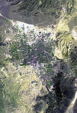
Las Vegas Valley is a basin located in the U.S. state of Nevada. The valley in the northwest section is a northwest-by-southeast trending area, and trending parallel to Las Vegas Wash, lies at the northeast of the Spring Mountains massif.
Contents
U.S. Route 95 leaves Las Vegas' northwest and goes northwesterly through the northwest valley section, with Las Vegas Wash about 2 miles (3 km) northeast. U.S. 95 lies on the southwest perimeter of the valley bottomlands, and small alluvial fan areas from the northeast Spring Mountains border southwest.
A "distorted surface", a playa-like region, occurs at the farthest northwest area, for about 15 to 18 miles (24 to 29 km), starting from Nevada Route 157. At Nevada Route 156, 10 miles (16 km) northwest, the distorted surface, bottom land turns north, a 6 miles (9.7 km) area in length and about 3 miles (4.8 km) wide. It lies at the south drainage section of the Three Lakes Valley, where a water divide separates Dog Bone Lake in the valley's center from the southwest washes that drain into the Las Vegas Valley (upland Las Vegas Wash).
The Corn Creek Dunes lie about 5 miles (8.0 km) southwest of Route 156's intersection with U.S. 95, and they are slightly northeast of Las Vegas Wash.
Las Vegas Valley
The Las Vegas Valley is an area about 1,600 square miles (4,100 km2). All perimeters, except the northwest, are foothills or mountain ranges, with all highway routes entering the foothills; this includes the Interstate 15 to the southwest, as it climbs to Jean Pass (north), before traversing Ivanpah Valley. Only the U.S. Route 95 northwest follows an actual valley. The northwest section, thus describes the entire landform as a central, and large valley with an attached feeder valley northwest, and in this case the northwest source, and actual course of the Las Vegas Wash.
The valley is a fault-bounded structural and hydrologic basin made of alluvial-fan deposits. There are several aquifers contained within the valley including the Las Vegas Aquifer. These heavily depleted water sources exist at about 660–980 feet (200–300 m) in depth. As of 1986, estimate show that the valley floor in Downtown Las Vegas has subsided by about 6.2 feet (1.9 m) and about 2.9 feet (0.88 m) along The Strip as a result of pumping from these aquifers.
The valley is an active earthquake zone crossed by multiple fault and thrust lines. These include the 20-mile (32 km) long Frenchman Mountain Fault capable of a magnitude 7 event, Whitney Mesa Fault, Cashman Fault, Valley View Fault, Decatur Fault, Eglington Fault and the West Charleston Fault.
Great Basin Divide
The Great Basin Divide is represented in southeast Nevada by a circuitous path, that in the east, enters Nevada at the Clover-Bull Valley Mountains, and in the south leaves Nevada at the New York Mountains. At the northwest of the entire Las Vegas region, and also the northwest section upland area of the watershed of Las Vegas Wash, the Great Basin Divide, changes direction in the Spring Mountains, from a north-south transect, to leave the massif at the northeast, in the foothills, and enter the east-west transect, mostly at the southern perimeter of the north-south mountain ranges, on the Las Vegas north perimeter.