
 | ||
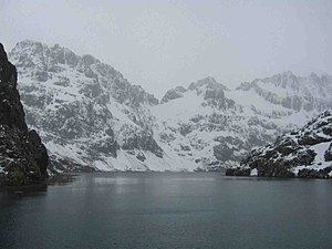
Larsen Harbour is a narrow 2.6 miles (4.2 km) long inlet of indenting volcanic rocks and sheeted dykes known as the Larsen Harbour Formation. It is a branch of Drygalski Fjord, entered 2.5 miles (4 km) west-northwest of Nattriss Head, at the southeast end of South Georgia. It was charted by the German Antarctic Expedition, 1911–12, under Filchner, who named it for Captain Carl Anton Larsen a Norwegian Antarctic Explorer, who made significant contributions to the exploration of Antarctica. The most significant being the first discovery of fossils, for which he received the Back Grant from the Royal Geographical Society. Larsen is also considered the founder of the Antarctic whaling industry and the settlement at Grytviken, South Georgia.
Contents
- Map of Larsen Harbour SIQQ 1ZZ South Georgia and the South Sandwich Islands
- Zodiac ride in larsen harbour south georgia
- References
Map of Larsen Harbour, SIQQ 1ZZ, South Georgia and the South Sandwich Islands
The peaks and mountain crests surrounding the almost land-locked harbour was described by Sir Ernest Shackleton's photographer Frank Hurley as "most beautiful and exceeding all in grandeur even that of Milford Sound ".
The Niall Rankin expedition aboard the Albatross, spent some time here as they studied the Weddell seal colony before going on to Esbensen Bay.
The area is rat-free, allowing species such as the South Georgia pipit, and burrowing petrels and prions to thrive. Mountains descend steeply into the sea here, and various glaciers calve into the sea.