Max. width 3.5 km (2.2 mi) References NVE Area 26.38 km² Shore length 64 km | Max. length 17 km (11 mi) Surface area 26.38 km (10.19 sq mi) Surface elevation 43 m Length 17 km | |
 | ||
Reference Norwegian Water Resources and Energy Directorate | ||
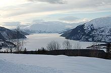
Langvatnet is a lake in the municipality of Rana in Nordland county, Norway. The 26.38-square-kilometre (10.19 sq mi) lake lies just northwest of the town of Mo i Rana. The lake flows out into the river Langvassåga just north of Mo i Rana Airport, Røssvoll. The lake used as a reservoir for the Langvatn hydroelectric power plant in Ytteren, just down the hill from the lake.
Map of Langvatnet, Rana, Norway
References
Langvatnet (Rana) Wikipedia(Text) CC BY-SA
