
Country Thailand Tambon 6 Time zone THA (UTC+7) Area 447 km² Province Lopburi Province | Seat Lam Sonthi Muban 49 Postal code 15190 Population 34,480 (2012) | |
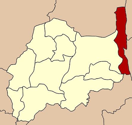 | ||
Lam Sonthi (Thai: ลำสนธิ, [lām sǒn.tʰíʔ]) is the easternmost district (Amphoe) of Lopburi Province, central Thailand.
Contents
Map of Lam Sonthi District, Lopburi, Thailand
History
Lam Sonthi was created as a minor district (King Amphoe) on April 1, 1989, by splitting off five tambon from the district Chai Badan. It was upgraded to a full Amphoe on December 5, 1996. The sixth tambon Khao Noi was created in 1994.
Geography
The name Lam Sonthi comes from the small Sonthi River that originates in the Sap Langka Wildlife Sanctuary, the last forest of Lopburi, located in Tambon Kut Ta Phet in the very north of the district.
Neighboring districts are (from the north clockwise) Si Thep and Wichian Buri of Phetchabun Province, Thep Sathit of Chaiyaphum Province, Thepharak, Dan Khun Thot and Sikhio of Nakhon Ratchasima Province, Muak Lek of Saraburi Province, and Tha Luang and Chai Badan of Lopburi Province.
To the east the district boundary is formed by the Phang Hoei ridge, while the boundary in the northwest is formed by the Luak ridge, both ridges part of the Phetchabun mountain range.
Administration
The district is subdivided into 6 subdistricts (tambon), which are further subdivided into 49 villages (muban). There are no municipal (thesaban) areas, and further 4 Tambon administrative organizations (TAO).