
Cities Wister | Surface elevation 146 m | |
 | ||
Primary inflows Water volume 49,400 acre·ft (0.0609 km) (conservation)383,000 acre·ft (0.472 km) (full flood control) Inflow source Poteau River, Fourche Maline | ||
Lake wister state park southeastern oklahoma november 2015 camping hiking
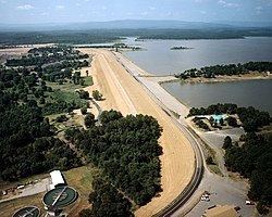
Lake Wister is a reservoir in Le Flore County, in southeast Oklahoma. The lake is created by the Poteau River and the Fourche Maline creek. Wister Lake was authorized for flood control and conservation by the Flood Control Act of 1938. The project was designed and built by the Tulsa District Corps of Engineers. Construction began in April 1946, and the project was placed in full flood control operation in December 1949.[2]
Contents
- Lake wister state park southeastern oklahoma november 2015 camping hiking
- Map of Wister Lake Oklahoma USA
- HistoryEdit
- DescriptionEdit
- References
Map of Wister Lake, Oklahoma, USA
HistoryEdit
Lake Wister was authorized for flood control and conservation by the Flood Control Act of 1938. The project was designed and built by the Tulsa District Corps of Engineers at a cost of $10.5 million. Construction began in April 1946, and the project was placed in full flood control operation December 1949. It is now part of Lake Wister State Park. The lake is named for the nearby city of Wister, Oklahoma. Other nearby cities are Heavener and Poteau.
The area around the lake has been inhabited for thousands of years. There are numerous mounds in the area that were created by prehistoric Native Americans.
DescriptionEdit
The lake is located within Ouachita National Forest. It has a surface area of 7,300 acres (3,000 ha) and a shoreline of about 115 miles (185 km). The normal elevation is 478 feet, minimum elevation is 450 feet and the maximum is 503 feet. Design volume of water is 61423 acre-ft. It drains an area of 993 square miles.