
Primary outflows Eastman Brook Max. length 1.7 mi (2.7 km) Surface area 334 acres (1.35 km) Area 135 ha Length 2.7 km | Basin countries United States Max. width 0.5 mi (0.80 km) Surface elevation 401 m Mean depth 8.5 m Width 800 m | |
 | ||
Location | ||
88 lake tarleton rd warren nh 03279 warren nh 03279
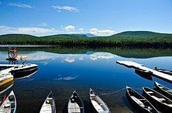
Lake Tarleton is a 334-acre (1.35 km2) water body located in Grafton County on the western edge of the White Mountains in New Hampshire, United States. The lake is located in the towns of Piermont and Warren. Water from Lake Tarleton flows via Eastman Brook west to the Connecticut River.
Contents
- 88 lake tarleton rd warren nh 03279 warren nh 03279
- Map of Lake Tarleton New Hampshire 03779 USA
- References
Map of Lake Tarleton, New Hampshire 03779, USA
Kingswood Camp for Boys is located on the lake. The Appalachian Trail runs nearby on Mount Mist, then continues north to Mount Moosilauke, with both mountains overlooking the lake.
The lake is classified as a cold- and warmwater fishery, with observed species including rainbow trout, brown trout, lake trout, smallmouth bass, chain pickerel, and horned pout.
Lake Tarleton State Park offers an unguarded swimming beach and opportunities for swimming, canoeing and fishing.