
Max. length 2,160 m (7,090 ft) Average depth 9.1 m (30 ft) Surface elevation 906 m Length 2.16 km | Surface area 1.99 km (0.77 sq mi) Max. depth 9 m (30 ft) Area 199 ha | |
 | ||
2014 fly fishing only c r river lim lake plavsko plav montenegro by tero
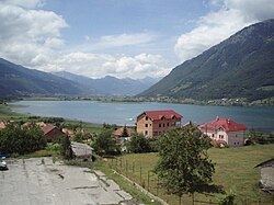
Lake Plav (Montenegrin: Plavsko jezero) is a lake in Plav municipality, in northeastern Montenegro.
Contents
- 2014 fly fishing only c r river lim lake plavsko plav montenegro by tero
- Map of Plavs Lake Montenegro
- References
Map of Plav's Lake, Montenegro
It is a glacial lake located between the Prokletije and Visitor mountain ranges at an altitude of 906 m above sea level, and extends north-south for some 2,160 m. Its average width is 920 m, and its maximum depth is nine meters.
It is the largest and most beautiful lake in Plav, and is also the best known tourist attraction in the area.
The area around the lake is ideal for trekking, hiking and mountain-biking and the lake itself is only one of a large number of mountain lakes that can be visited, whether it is for a quick swim or a relaxing picnic.
The whole Plav region nestles at the foot of the towering Prokletije mountain range and rests on the banks of Lake Plav. The lake itself stretches from north to south for nearly a mile.
The geology of Lake Plav and the surrounding lakes, streams and rock formations is very interesting. The lake itself is full of limestone caverns and there are many springs where water gushes forth from the earth.