
Surface area 198 acres (80 ha) Surface elevation 152 m Cities Seguin | Primary inflows Basin countries United States Max. depth 40 ft (12 m) Area 80 ha Inflow source Guadalupe River | |
 | ||
Similar Lake McQueeney, Lake Dunlap, Sebastopol, Los Nogales, Saffold Dam | ||
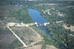
Lake Placid is a reservoir on the Guadalupe River one half mile (1 km) southwest of the town of Seguin in Guadalupe County, Texas. The reservoir was formed in 1928 by the construction of a dam on the river. Management of the dam and lake was assumed by the Guadalupe-Blanco River Authority on May 1, 1963. Lake Placid is a venue for outdoor recreation, including fishing, boating, and swimming.
Contents
Map of Lake Placid, Texas 78155, USA
Fish and plant lifeEdit
Lake Placid has been stocked with species of fish intended to improve the utility of the reservoir for recreational fishing. Fish present in Lake Placid include catfish, white crappie, sunfish, and largemouth and spotted bass. Vegetation in the lake includes cattail, pondweed, American lotus, spatterdock, rushes, water hyacinth, water lettuce, and hydrilla.
Recreational usesEdit
The only free public boat ramp and lake access is available off exit 605 of Interstate Highway 10.