
 | ||
Peak Unnamed (Lake Mountains (approx. center)) Length 15 mi (24 km) N-S (arc-shape, curved east) Width 8 mi (13 km) (at center, narrower north/south) Communities(at foothills) ListLehiClintonEagle MtnFairfieldCedar FortMosida (site) Borders on Oquirrh Mountains-NWSalt Lake City & Valley-NUtah Lake-NE, E, & SEGoshen Valley-SEast Tintic Mountains-SSWCedar Valley-W | ||
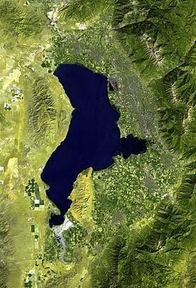
The Lake Mountains are a 15-mile (24 km) long mountain range located in west Utah County, Utah in western Utah Valley; the range forms the northwest border of Utah Lake, and its proximity allows its use for communication towers, mostly in its north section, bordering Eagle Mountain.
Contents
Map of Lake Mountains, Utah, USA
DescriptionEdit
The range is arc-shaped, curved to the east, on the northwest shore of Utah Lake. The Lake Mountains have no prominent peaks, but a central ridgeline, about 5-mi (8 km) long, trends slightly NNW by SSE. About nine named canyons are on the east, with Utah Lake; the west has fewer canyons, and Wiley Canyon on the west is slightly north of the range's center.
The arc-shaped east mountain range perimeter contains Utah Route 68 on the lakeshore. In Cedar Valley (Utah) on the west side, Utah Route 73 travels east, then northeast, around the northern perimeter of the mountain range.
TourismEdit
Cedar Valley, at Fairfield contains the Camp Floyd/Stagecoach Inn State Park; it is on the Pony Express National Historic Trail.