
Average depth 16 ft (4.9 m) Shore length 7.9 mi (12.7 km) Surface elevation 295 m | Surface area 356 acres (144 ha) Max. depth 36 ft (11 m) Area 144 ha Mean depth 4.88 m | |
 | ||
Location | ||
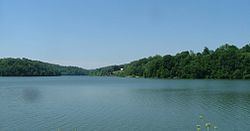
Lake Linville is a 356-acre (1.44 km2) reservoir in Rockcastle County, Kentucky. It was created in 1968 by the construction of the earthen Renfro Dam, 72 feet high with a length of 1100 feet, owned and operated by the Commonwealth of Kentucky. The dam is a highway fill embankment along Interstate 75.
Contents
Map of Lake Linville, Kentucky, USA
FacilitiesEdit
Facilities include a launching ramp, boat dock, and parking area. Boats, live bait, and tackle are available.
FisheryEdit
Species in the lake include largemouth bass, spotted bass, white crappie, hybrid bass, channel catfish, bluegill, longear sunfish, carp, and yellow bullhead.
References
Lake Linville Wikipedia(Text) CC BY-SA