
Basin countries Greece Area 37 km² Mean depth 6 m Width 46 km Cities Volos | Lake type Drained Lake Max. length 25 km (16 mi) Catchment area 37,000 km² Length 25 km | |
 | ||
Primary inflows Primary outflows Pinios River, evaporation | ||
Lake Karla (Greek: Λίμνη Κάρλα) is a former lake that sits at 60 to 80 m (200 to 260 ft) above sea level making it the only one in the plain of Thessaly. The lake is located at the northern end of the Magnesia regional unit in the Pineios basin, adjacent to Pelion and Maurovouni mountains. On the eastern part of the lake the lies the town of Kanalia.
Contents
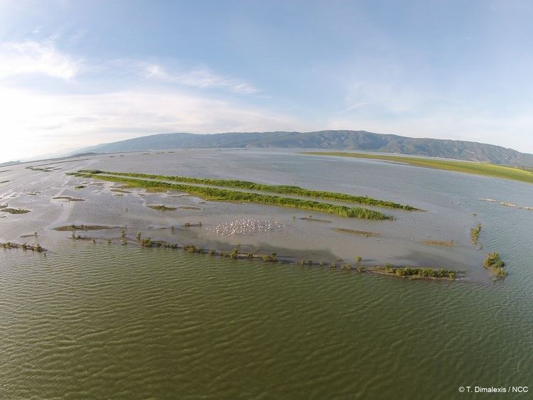
Map of Lake Karla, Armenio 415 00, Greece
Name
Its first name was Voivis (Ancient Greek: Βοιβηίς) and was taken from the nearby ancient city of Voivis which today is located at Kanalia
Restoration of the lake
Lake Karla, some 300 km (190 mi) north of Athens, was an 180 km2 lake that was completely drained in 1962 to gain land for agriculture. The lake was part of the ancient Greek mythology (the god Apollo was married on its shores). Before its drainage, it was the site of a unique fishermen culture, with the fishermen spending some nine months of the year in reed huts that they built on the lake. The lake fisheries were an important tradition and to some extent a significant economic activity.
For these reasons, and because agriculture was never successful in the saline soils of the former lake bed, the local population supports an ambitious project to restore the lake. The restoration will reflood only 50 of the original 180 km2 of the former lake. The project represents a 100 million ECU investment that would be financed with the support of the European Commission. Some technical aspects still require further elaboration in order to ensure that it is environmentally sound, but the project has so much popular and political support that most likely it will go ahead. If so, it would represent one of the most ambitious wetland restoration projects and a good case study for the Ramsar Convention.
Other notable facts
The site includes Mavrovouni mountain, two water reservoirs in former Lake Karla and the spring Kefalovryso in Velestino. Mavrovouni (390 km2 or 96,000 acres, max elevation 1,054 m or 3,458 ft) extends between Ossa and Pilio mountains and is today restored totally in Magnesia. It mainly consists of schist and, in less extent, of limestone. The marine area covers 2% of the site, the terrestrial area covers 96% and the reservoirs cover 2%
Its northeast side ends in steep cliffs in the Aegean Sea. At the higher zone, it is mainly covered by oak forests (especially Quercus conferta) and at lower parts by beech and chestnut forests. Maquis covers the lower zone. At the eastern part of the mountain it is very dense and dominated by holm oak (Quercus ilex). The rest of maquis is dominated by kermes oak and wild olive and has deteriorated as a result of intense grazing. This area is used for pasture by high numbers of farm animals. Mavrovouni also includes ravines, rock formations, grasslands, phrygana and agricultural land. A significant number of streams runs the mountain, most of them drying in summer. At the banks of the streams there are plane trees, alders, poplars and willows.
The two water reservoirs, one near Stefanovikio (4 km2 or 990 acres) and the other near Kalamaki (2 km2 or 490 acres), were constructed in 1988 for irrigation purposes in the area of the former Lake Karla. Their water flows in from the river Pineios through the Asmaki stream. However, industrial and agricultural wastes flow into the reservoirs. They are possibly eutrophic and a rapid increase of reedbeds into them is observed. Kefalovryso spring has suffered the effects of human activities. Its area has been reduced, it has lost its natural vegetation and possibly its native fishes, as well. Now it is used as a pond for the production of commercial (trout etc.) and exotic fishes.