
Primary inflows Max. width 6 km (3.7 mi) Length 32 km Outflow location Umba River | Primary outflows Umba River Max. length 32 km (20 mi) Surface elevation 52 m Width 6 km Inflow source Umba River | |
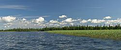 | ||
Kanozero (Russian: Канозеро) is a lake on the Umba River in Murmansk Oblast in Russia.
Map of Lake Kanozero, Murmansk Oblast, Russia, 184227
The lake is 32 km long and between three and six kilometers wide. It is situated about halfway between Lake Umbozero and the White Sea. The Umba river enters the lake on the east side, about five kilometers from its northern end. Two of the Umba's main tributaries, the Kana and the Muna rivers, flow into the Umba through Lake Kanozero.
The lake has two outflow channels: At Zasheyek-Kanozero at the very southern end of the lake the Rodvinga channel exits through the Kanoserskiy Falls, while five kilometers to the northeast the Kitsa channel leaves the lake over the Padun Falls. The channels rejoin in Lake Ponchozero about ten kilometers downriver.
Lake Kanozero is also known for the Kanozero Petroglyphs.