
Max. length 12 mi (19 km) Area 6.07 km² Surface elevation 186 m | Primary inflows Surface area 1,500 acres (610 ha) Length 19.3 km Mean depth 4.88 m Inflow source Tippecanoe River | |
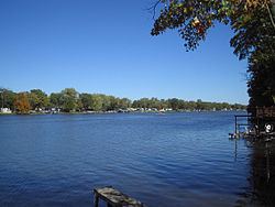 | ||
Lake Freeman is a reservoir outside of Monticello, Indiana formed in 1925 by the completion of the Oakdale Dam. Lake Freeman, together with its sister lake, Lake Shafer is part of the Twin Lakes region, a popular summer recreational area centered on the town of Monticello, Indiana.
Map of Lake Freeman, Indiana 47960, USA
Construction of the Oakdale Dam began in 1923 and was completed in 1925, damming the waters of the Tippecanoe River. The earthen dam is 58 feet high, has a maximum capacity of 40,540 acre-feet, normal capacity of 26,140 acre feet, and is owned by the Northern Indiana Public Service Company.
Compared to the more commercial lake, Lake Shafer, Lake Freeman remains more privatized and residential. Lake Freeman, is however, home of the Madam Carroll, a pleasure excursion vessel, 36 feet (5.5 m) in width and 135 feet (41/5) in length.
Lake Freeman is roughly 1,500 acres (6 km²) in area and has a shoreline of 50 miles (80 km). Depths vary from 7 feet (2 m) to 45 feet (15 m) at the Oakdale Dam.