
Primary inflows Max. length 3 km (1.9 mi) Surface area 4.2 km (1.6 sq mi) Area 4.2 km² Length 3 km Catchment area 3.38 km² | Primary outflows subsurface Max. width 2.4 km (1.5 mi) Surface elevation 877 m Mean depth 81 m Width 2.4 km Basin countries Tanzania, Kenya | |
 | ||
Location Africa; at the border between Tanzania and Kenya | ||
Lake chala campsite campsite at crater lake chala
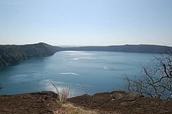
Lake Chala, also known as Dschalla, is a crater lake in a caldera on the borders of Tanzania and Kenya on the eastern edge of Mount Kilimanjaro, not far from the town of Moshi and 8 km north of Taveta. Depending on the time of year, it ranges in colour from deep blue to turquoise and green, it is surrounded by a 100 metres high crater rim. The lake is fed by groundwater flows, which come from Mount Kilimanjaro, fed and drained under ground with a rate of about 10 million m³ / year. Even the Chala loses volume. Its level had dropped in the last 6 years, by 2.4 metres, at the start of 2011 the water level has risen again by over 1 metre.
Contents
Map of Lake Chala
The lake is home to the endemic Lake Chala tilapia (Oreochromis hunteri), which is now considered Critically Endangered on the IUCN red list of threatened species
Crocodiles were introduced to Lake Chala in the early 1900s, and in 2002, a woman was killed by a rare Nile crocodile (Crocodylus niloticus) while swimming in the lake. Since then the local fishermen, tired of having their nets ripped to pieces, started an eradication programme by shooting and poisoning. It is doubtful if any crocodiles remain in the lake today.
This stunning volcanic area is rapidly growing in tourism and it is now possible to stay at Lake Chala at the new camp on the Tanzanian side.