
Surface area 0.58 km (0.22 sq mi) Area 58 ha Length 2.4 km Outflow location Amtkeli River | Primary inflows Max. length 2.4 km (1.5 mi) Surface elevation 512 m Catchment area 153 km² Year built 3 October 1891 Inflow source Amtkeli River | |
 | ||
Primary outflows Jampali (through sinkholes)Amtkeli | ||
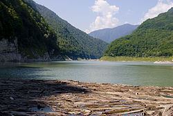
Lake Amtkeli or Amtkel (Abkhaz: Амтҟьал; Georgian: ამტყელის ტბა; Russian: Амткел) is a lake in the Gulripshi District of Abkhazia, Georgia that was formed on 3 October 1891 when an earthquake caused a landslide on the south-western slope of Mt. little Shkhapach into the valley of the Amtkeli River.
Contents
Map of Tba Amtqeli
Geography
Lake Amtkeli is fed by the Amtkeli River, but only a small part of its water percolates through the obstructing rubble back into the river. The greater part leaves the lake through underground passages to the Jampal River. Due to the lake's limited discharge capacity, its water level rises strongly during snowmelt in May, leading to annual fluctuations of up to 40 m (131 ft) in the lake's average 512 m (1,680 ft) height above sea level and 65 m (213 ft) maximal depth, and increasing its length from 2.4 km (1.5 mi) to 4 km (2.5 mi). The average surface area of Lake Amtkeli is 0.58 km2 (0.22 sq mi), and its drainage basin measures 153 km2 (59 sq mi).
Due to the lake's origin, its underwater slopes are steep, following the surface slopes.
Environment
Lake Amtkeli is home to trout, chub, nase, barbel and spirlin.
In July and August, the lake's average surface temperature is 20 °C (68 °F), in Winter it rarely freezes over.
Human settlement
The village of Azanta is located next to lake Amtkeli, and some of its inhabitants keep fishing boats on its shore.