
Country South Africa District Uthukela Established 1850 Area 91.97 km² Area code 036 | Municipality Alfred Duma Postal code (street) 3370 Local time Saturday 4:30 AM Number of airports 1 | |
 | ||
Weather 12°C, Wind NE at 3 km/h, 83% Humidity | ||
Ladysmith is a town in the Uthukela District of KwaZulu-Natal, South Africa. It is 230 kilometres (140 mi) north-west of Durban and 365 kilometres (227 mi) south of Johannesburg. Important industries in the area include food processing, textile and tyre production. Tyres are produced by Sumitomo Rubber South Africa in the nearby town of Steadville.
Contents
- Map of Ladysmith South Africa
- History
- Battle of Ladysmith
- Siege of Ladysmith
- Relief of Ladysmith
- Geography
- Flooding
- Climate
- Architecture
- Air
- Rail
- Road
- Primary
- Secondary
- Special schools
- Tertiary
- Media
- The Second Boer War
- Music
- Sport
- Military
- Famous people
- References
Map of Ladysmith, South Africa
Ladysmith is the seat for both the Alfred Duma Local Municipality and the Uthukela District Municipality.
History
In 1847 after buying land from the Zulu king Mpande, a number of Boers settled in the area and called it the Republic of Klip River with Andries Spies as their commandant. The republic was annexed by the British in the same year and on 20 June 1850 was proclaimed a township called Windsor. On 11 October 1850 the name was changed to Ladysmith after Juana María de los Dolores de León Smith also known as "Lady Smith," the Spanish wife of Sir Harry Smith, the Governor of the Cape Colony. Sir Harry Smith was the British general governor of Cape Colony and high commissioner in South Africa from 1847 to 1852.
A fort was built in 1860 to protect the villagers from the Zulu.
Battle of Ladysmith
During the Second Boer War British commander Lieutenant General Sir George White made Ladysmith his centre of operations for the protection of Natal against the Boer forces. Starting on 29 October 1899 a number of short lived battles were fought for control of the town, but after suffering heavy casualties the British forces retreated to Ladysmith and the Boer forces did not make use of the opportunity to follow up the attack and take control of the town.
Siege of Ladysmith
Following the Battle of Ladysmith, whilst British forces under Lieutenant General Sir George White regrouped in the town, Boer forces surrounded Ladysmith. The siege lasted 118 days, from 2 November 1899 to 28 February 1900, during the most crucial stage of the war. Approximately 3,000 British soldiers died during the siege.
Relief of Ladysmith
Three attempts by General Sir Redvers Buller to break the siege resulted in defeat for the British forces at the battles of Colenso, Spion Kop and Vaal Krantz. On 6 January 1900 the Boer forces of Commandant-General Piet Joubert attempted to end the siege by taking the town before the British could launch another attempt to break the siege. This led to the battle of Platrand (or Wagon Hill) south of the town.
Buller finally broke the siege on 28 February 1900 after defeating the Boers by using close cooperation between his infantry and artillery.
Sir Winston Churchill, then a young war correspondent for The Morning Post (London), was present at the Relief of Ladysmith after having been taken prisoner (between Ladysmith and Colenso) and escaping earlier during the war.
Mohandas Gandhi and the stretcher-bearing corps that he established earlier during the war was involved in a number of actions that took place in and around Ladysmith during the Relief.
Geography
Ladysmith is located on the banks of the Klip River ("stone river"), with the central business district and a large part of the residential areas located within the flood basin of the river. It is on the foothills of the Drakensberg mountains, about 26 km from the Van Reenen pass.
Flooding
Since it was established the town has suffered severely from flooding of the Klip River. During the 110 years up to 1997 with the completion of the Qedusizi Dam, 29 serious floods have occurred. Minor flooding occurred almost every year.
The worst flooding in 30 years occurred in 1996 leading to R500 million in damages and the evacuation of 400 families.
Efforts to control the flooding date back to the 1940s. In 1949 the Windsor Dam was completed, but this dam silted up very fast and was not an effective means of flood control.
Climate
Ladysmith has a subtropical highland climate (Cwb, according to the Köppen climate classification), with warm summers and cool, dry winters. It borders on a humid subtropical climate (Cwa). The average annual precipitation is 639 mm (25 in), with most rainfall occurring during summer.
Architecture
The Soofi Mosque on the banks of the Klip River was originally built sometime between 1895 and 1910, but it was greatly extended in the 1960s.
Other building of interest are the Siege Museum, originally built in 1884 as a marketplace and the Town Hall, damaged by Boer artillery during the Second Boer War.
Air
Ladysmith is served by a small airport, (IATA: LAY, ICAO: FALY) is located on the outskirts of town just below Platrand at 28°34′48″S 29°45′10″E. The Aerodrome is managed and operated by JetVision Holdings Pty Ltd.
Rail
The Danskraal Yard is located on the Free State main line and the Glencoe–Vryheid line and acts as a depot for train marshalling and maintenance as well as rail maintenance.
The passenger station is located some distance away from Danskraal close to the Central Business District.
Road
The N11 links Ladysmith with Bergville and Newcastle, while the R103 provides access to Colenso, KwaZulu-Natal and the N3.
Traffic traveling between Durban and Johannesburg used to pass through Ladysmith up until the late 1980s, but the completion of the N3, bypassing Ladysmith 15 kilometres (9.3 mi) to the west, has caused a dramatic drop in traffic volumes through this town as well as others that are now bypassed.
Primary
Secondary
Special schools
Tertiary
Media
The only sold local newspaper in Ladysmith is the Ladysmith Gazette. The Ladysmith Gazette is just over a century old, and is believed to have been established in 1902. The Ladysmith Gazette is part of the Caxton Group of newspapers. One of two free local newspapers is the Ladysmith Herald. The other free newspaper is the Times of Ladysmith.
The Second Boer War
A large number of the Second Boer War Battlefields around Ladysmith have been preserved as memorial sites. Monuments and memorials to those who died during the battles have been erected at most of them.
Siege museum
Located next to the town hall there is a small museum detailing the battles and history at the time of the Siege. The museum was opened in 1985 and holds around 60,000 documents related to the Siege and Boer War.
Platrand/Wagon Hill
Media related to Platrand Memorials at Wikimedia CommonsLocated just south of the town, this area saw action during the Relief of Ladysmith. The Burgher Memorial on Wagon Hill was erected in honour of Boer forces killed during the siege and relief of Ladysmith.
On Platrand there are memorials to the Imperial Light Horse, the Devonshire Regiment, the Earl of Ava and a number of others.
Castor and Pollux
Two RML 6.3 inch Howitzers used by the British during the Siege stand in front of the Town Hall.
Mohandas Gandhi statue
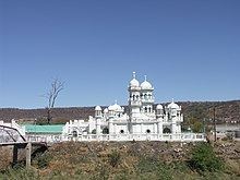
A statue of Mohandas Gandhi can be seen at the Lord Vishnu Temple.
Music
Ladysmith is the hometown of Joseph Shabalala, founder of the group Ladysmith Black Mambazo.
Sport
Thulani "Sugar Boy" Malinga, a champion boxer was born in Ladysmith.
Elmer Symons, Dakar Rally rider who was killed in the 2007 edition while leading the Marathon class.
Military
5 South African Infantry Battalion is based in Ladysmith. A military shooting range is located on the outskirts of the town between the Aerodrome and Platrand.