
Country Germany | ||
 | ||
Main source Southwest of Sprakensehl96 m Landmarks Villages: Auermühle, Lüsche, Steinhorst, Wohlenrode, Hohnhorst, Jarnsen, Beedenbostel, Lachendorf, Lachtehausen | ||
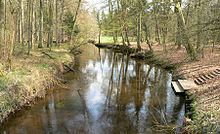
The Lachte is a roughly 38-kilometre (24 mi) long right-hand tributary of the River Aller in the Südheide Nature Park in the north German state of Lower Saxony.
Contents
Map of Lachte, Germany
CourseEdit
The Lachte rises in the northern part of the district of Gifhorn southwest of Sprakensehl. It flows initially southwest, feeds a 5-kilometre (3.1 mi) long row of fish ponds near the Auermühle Estate (Gut Auermühle) and is then joined from the left by the Kainbach stream and, beyond the town of Steinhorst (which has a water wheel in its coat of arms), the Jafelbach. In Steinhorst a stony ford crosses the river. Near Beedenbostel, Celle district, the Lutter and the Aschau join the Lachte from the right. Near Lachendorf the river swings west and discharges into the Aller near Lachtehausen, a village within Celle district.
In 1997 the "Upper Lachte, Kainbach, Jafelbach" Nature Reserve was opened with an area of 1,090 hectares (2,700 acres). The Lachte and the Lutter with their tributaries, which both run through the eastern part of the Südheide Nature Park, form a river system with numerous branches that covers an area of about 2,450 hectares (6,100 acres) and was designated a nature reserve (Naturschutzgebiet) in 2007.
Although only following the western section of the river, the narrow gauge line from Celle to Wittingen was known as the Lachte Valley Railway.