
Type crater lake Max. length 0.09 km (0.056 mi) Surface elevation 1,103 m | Primary inflows Max. width 0.07 km (0.043 mi) | |
 | ||
Basin countries Guadeloupe, Département d'outre-mer, France | ||
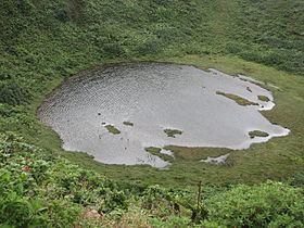
Lac Flammarion is a crater lake in Guadeloupe, which straddles the communes of Gourbeyre and Capesterre. It is situated at an altitude of 1,103 metres (3,619 ft), and measures 90 metres (300 ft) by 70 metres (230 ft).
Map of Lac Flammarion, Guadeloupe
The lake is entirely filled by rainfall, which is usually about 8,000 millimetres (310 in) per year. The water is acidic with a pH ranging between 4.5 and 5. Its temperature ranges between 18 and 19 °C.
Flammarion is free of vegetation, but rather rare species that prefer the acidic conditions grow on its shores, such as Blechnum l'herminieri, Isachne rigidifolia and Juncus guadeloupensis, an endemic species of rush.
References
Lac Flammarion Wikipedia(Text) CC BY-SA