
Canton Mouthe Area 22.12 km² | Population (2012) 1,137 Local time Friday 5:17 PM | |
 | ||
Region Bourgogne-Franche-Comté Intercommunality Mont d'Or et les Deux Lacs Weather 10°C, Wind NE at 13 km/h, 54% Humidity Points of interest Réserve naturelle nationale, Maison de la Réserve, Lac de Remoray | ||
Labergement-Sainte-Marie is a commune in the Doubs department in the Bourgogne-Franche-Comté region in eastern France.
Contents
Map of 25160 Labergement-Sainte-Marie, France
Geography
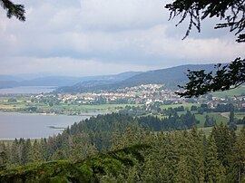
The commune is situated 18 km (11 mi) south of Pontarlier on between the lakes of Remoray and Saint-Point. It is dominated by the Bois de Ban and the forests of Fuvelle and Grande Côte.
History
The commune was formed from two former communes Labergement-Sainte-Marie and Granges-Sainte-Marie in 1972. Both took their names from the Cistercian abbey of Mont-Sainte-Marie.
Tourism
The rich natural resources of the commune attract many visitors to the lakes and forests. There are numerous hotels, hostels, and furnished apartments available for the visitor, as well as a campground.
References
Labergement-Sainte-Marie Wikipedia(Text) CC BY-SA