
Country Canada Effective January 1, 1983 Time zone EST (UTC−5) Area 13,932 km² Province Québec | Region Outaouais County seat Gracefield Website www.mrcvg.qc.ca Population 20,530 (2011) Area code 819 | |
 | ||
Points of interest Parc régional du Mont Morissette Destinations Maniwaki, La Vérendrye Wildlife R, Lac‑Sainte‑Marie, Grand‑Remous, Baskatong Reservoir | ||
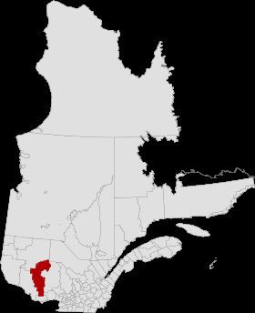
La Vallée-de-la-Gatineau (The Valley of the Gatineau) is a regional county municipality in the Outaouais region of western Quebec, Canada. The seat is in Gracefield. It is named for its location straddling the Gatineau River north of Low. It was incorporated on January 1, 1983.
Contents
- Map of La VallC3A9e de la Gatineau Regional County Municipality QC Canada
- Subdivisions
- Access Routes
- References
Map of La Vall%C3%A9e-de-la-Gatineau Regional County Municipality, QC, Canada
It consists of two cities, fifteen municipalities, and five unorganized territories. The area also has two Algonquin communities, Kitigan Zibi (south of Maniwaki) and Rapid Lake in the heart of the La Vérendrye Wildlife Reserve.
The territory of the Gatineau Valley is bordered to the south by the Les Collines-de-l'Outaouais Regional County Municipality and to the east by the Antoine-Labelle Regional County Municipality. Numerous lakes abound in area, including everything from the small Lac des Pins to 31 Mile Lake.
Subdivisions
There are 22 subdivisions within the RCM:
Access Routes
Highways and numbered routes that run through the municipality, including external routes that start or finish at the county border: