
Postal codes 6980, 6982-6984, 6986 | Area codes 084 Local time Friday 10:26 AM | |
 | ||
Weather 8°C, Wind SE at 6 km/h, 67% Humidity Points of interest Château Féodal, Musée de la Bataille des Arde, Le Parc à Gibier de La Roche, La Roche‑en‑Ardenne Castle, Ourthe | ||
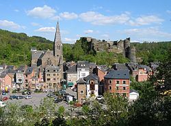
La Roche-en-Ardenne is a Walloon municipality of Belgium located in the province of Luxembourg and the arrondissement of Marche-en-Famenne. Lying beside a bend in the River Ourthe, the small town of La Roche-en-Ardenne is one of the most popular tourist destinations in the Ardennes.
Contents
- Map of La Roche en Ardenne Belgium
- White pigeon visit castles episode 4 chateau de la roche en ardenne
- Geography
- History
- Economy
- Governance
- Sights
- References
Map of La Roche-en-Ardenne, Belgium
On 1 January 2007 the municipality, which covers 147.52 km², had 4,348 inhabitants, giving a population density of 29.5 inhabitants per km².
White pigeon visit castles episode 4 chateau de la roche en ardenne
Geography
La Roche-en-Ardenne is located between the E25 Liège-Luxembourg and the N4 motorways. More than half of the municipal area (about 85 square kilometres (33 sq mi)) is covered in forests and 50 square kilometres (19 sq mi) is arable land, and only 8 square kilometres (3.1 sq mi) has been built on. The division between deciduous and coniferous forests is more or less equal.
The municipality consists of the following sub-municipalities: La Roche-en-Ardenne proper, Beausaint, Halleux, Hives, Ortho, and Samrée. Other population centers include Bérismenil, Buisson, Cielle, Floumont, Herlinval, Hubermont, Lavaux, Maboge, Mierchamps, Mousny, Nisramont, Ronchampays, Ronchamps, Roupage, Thimont, Vecmont, and Warempage.
History
La Roche is believed to have first been settled in the Neolithic era. There is a Celtic archaeological site dating between 850 and 520 BC.The Romans built a fort there following their conquest of Gaul and the Ardennes.
The town's medieval castle was in use between the 9th and 18th centuries. It provided protection to the many barges that plied their trade along the local river systems. In 1331, permission to build city walls was given by John the Blind, King of Bohemia and Poland and a Count of Luxembourg.
In World War II, the town suffered severe damage. Having been liberated by the Allies in September 1944, the town was recaptured by the Germans in December, during the Battle of the Bulge. The subsequent Allied bombing raids resulted in the town being liberated once more in January 1945, but left much of the town destroyed, and 116 residents dead. There is an American Sherman M4A1 tank and a British Achilles SP 17pdr displayed as monuments to the town's liberation. In town also is a memorial to the 82nd Armored Reconnaissance Battalion
In 1976 there was a merger of administrative districts in the area that resulted in the municipality of La Roche-en-Ardennes. Beausaint, Halleux, Hives, Ortho and Samrée were joined by Marcourt, formerly within the municipality of Rendeux.
Economy
Hiking, kayaking, and mountain biking are among the outdoor pursuits available here. The municipality's other main economic activity is agriculture. A business park was established on the plateau Vecmont to diversify the local economy.
The ceramic stoneware of La Roche (cobalt blue pottery, glazed with salt) is a local tradition known, initiated in 1836 by Henry Hoffman, a native of Ransbach in the Duchy of Nassau. The production was revived in 1878 by the family Kalb and continued until 2009 by several successors. A permanent exhibition on this tradition.
Governance
Like other Belgian Municipalities, the town is governed by a Communal College, whose membership is determined by the size of the population. In 2012, that was the Mayor, Town Clerk and 3 Alderman. An elected City Council determined what local taxes are spent and on what. As of 2012, this had a membership of 9 councillors.
Sights
There are three main archaeological sites:
There is the Parc à Gibier, a small wild game park on the top of the plateau above the town.