
 | ||
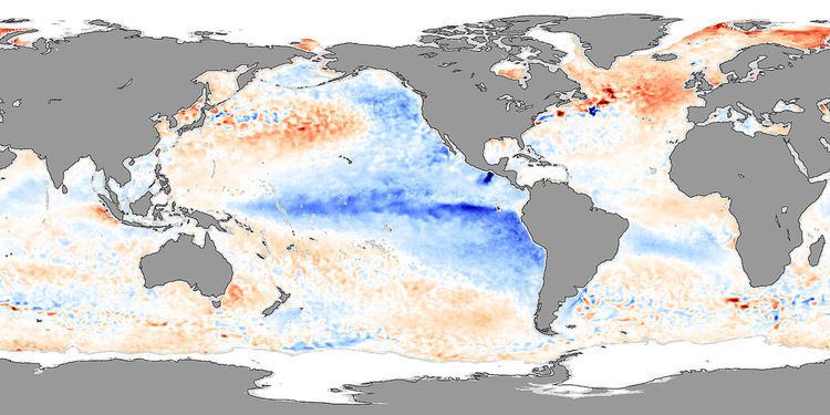
La Niña (/lɑːˈniːnjə/, [la ˈniɲa]) is a coupled ocean-atmosphere phenomenon that is the counterpart of El Niño as part of the broader El Niño–Southern Oscillation climate pattern. The name La Niña originates from Spanish, meaning "the little girl", analogous to El Niño meaning "the little boy". It has also in the past been called anti-El Niño, and El Viejo (meaning "the old man"). During a period of La Niña, the sea surface temperature across the equatorial Eastern Central Pacific Ocean will be lower than normal by 3 to 5 °C. In the United States, an appearance of La Niña persists for at least five months. It has extensive effects on the weather in North America, even affecting the Atlantic Hurricane Season.
Contents
- Definition
- Occurrences
- Impacts on the global climate
- Regional impacts
- Africa
- Asia
- North America
- South America
- La Nia diversity
- References
A timeline of all La Nina episodes between 1900 and 2017.
Definition
La Niña is the positive phase of the El Niño Southern Oscillation and is associated with cooler than average sea surface temperatures in the central and eastern tropical Pacific Ocean. However, each country and island nation has a different threshold for what constitutes a La Niña event, which is tailored to their specific interests. For example, the Australian Bureau of Meteorology looks at the trade winds, SOI, weather models and sea surface temperatures in the Nino 3 and 3.4 regions before declaring that a La Niña event has started. However, the Japan Meteorological Agency declares that a La Niña event has started when the average five month sea surface temperature deviation for the NINO.3 region is more than 0.5 °C (0.90 °F) cooler for 6 consecutive months or longer.
Occurrences
A timeline of all La Nina episodes between 1900 and 2017.
There was a relatively strong La Niña episode during 1988–1989. La Niña also formed in late 1983, in 1995, and a protracted La Niña event that lasted from mid-1998 through early 2001. This was followed by a neutral period between 2001 and 2002. The La Niña which developed in mid-2007, and lasted until almost 2009, was a moderate one. The strength of La Niña made the 2008 Atlantic hurricane season one of the five most active since 1944; 16 named storms had winds of at least 39 mph (63 km/h), eight of which became 74 mph (119 km/h) or greater hurricanes.
A new La Niña episode developed quite quickly in the eastern and central tropical Pacific in mid-2010, and lasted until early 2011. It intensified again in mid-2011 and lasted until early 2012 This La Niña, combined with record-high ocean temperatures in the north-eastern Indian Ocean, was a large factor in the 2010–2011 Queensland floods, and the quartet of recent heavy snowstorms in North America starting with the December 2010 North American blizzard. The same La Niña event was also a likely cause of a series of tornadoes of above-average severity that struck the Midwestern and Southern United States in the spring of 2011, and drought conditions in the South Central states including Texas, Oklahoma and Arkansas. Meanwhile, a series of major storms caused extensive flooding in California in December 2010, with seven consecutive days of non-stop rainfall, leading to one of the wettest Decembers in over 120 years of records. This is in contrast to the drier-than-normal conditions typically associated with La Niña in California.
In 2011, on a global scale, La Niña events helped keep the average global temperature below recent trends. As a result, 2011 tied with 1997 for the 11th warmest year on record. It was the second coolest year of the 21st century to date, and tied with the second warmest year of the 20th century. A relatively strong phase of La Niña opened the year, dissipated in the spring before re-emerging in October and lasted through the end of the year. When compared to previous La Niña years, the 2011 global surface temperature was the warmest observed. The 2011 globally-averaged precipitation over land was the second wettest year on record, behind 2010. Precipitation varied greatly across the globe. This La Niña contributed to severe drought in East Africa and to Australia's third wettest year in its 112-year period of records.
La Niñas occurred in 1904, 1908, 1910, 1916, 1924, 1928, 1938, 1949–51, 1954–56, 1964, 1970–72, 1973–76, 1983–85, 1988–89, 1995–96, 1998–2001, 2007–08, 2010–12, and 2016–17.
Impacts on the global climate
La Niña impacts the global climate and disrupts normal weather patterns, which as a result can lead to intense storms in some places and droughts in others.
Regional impacts
Observations of La Niña events since 1950, show that impacts associated with La Niña events depend on what season it is. However, while certain events and impacts are expected to occur during events, it is not certain or guaranteed that they will occur.
Africa
La Niña results in wetter-than-normal conditions in Southern Africa from December to February, and drier-than-normal conditions over equatorial East Africa over the same period.
Asia
During La Niña years, the formation of tropical cyclones, along with the subtropical ridge position, shifts westward across the western Pacific Ocean, which increases the landfall threat to China. In March 2008, La Niña caused a drop in sea surface temperatures over Southeast Asia by 2 °C. It also caused heavy rains over Malaysia, the Philippines, and Indonesia.
North America
La Niña causes mostly the opposite effects of El Niño, above-average precipitation across the northern Midwest, the northern Rockies, Northern California, and the Pacific Northwest's southern and eastern regions. Meanwhile, precipitation in the southwestern and southeastern states is below average. This also allows for the development of many stronger-than-average hurricanes in the Atlantic and fewer in the Pacific.
The synoptic condition for Tehuantepecer winds is associated with high-pressure system forming in Sierra Madre of Mexico in the wake of an advancing cold front, which causes winds to accelerate through the Isthmus of Tehuantepec. Tehuantepecers primarily occur during the cold season months for the region in the wake of cold fronts, between October and February, with a summer maximum in July caused by the westward extension of the Azores-Bermuda high pressure system. Wind magnitude is weaker during La Niña years than El Niño years, due to the less frequent cold frontal incursions during La Niña winters, with its effects can last from a few hours to six days.
In Canada, La Niña will, in general, cause a cooler, snowier winter, such as the near-record-breaking amounts of snow recorded in La Niña winter of 2007/2008 in Eastern Canada.
South America
During a time of La Niña, drought plagues the coastal regions of Peru and Chile. From December to February, northern Brazil is wetter than normal. La Niña causes higher than normal rainfall in the central Andes, which in turn causes catastrophic flooding on the Llanos de Mojos of Beni Department, Bolivia. Such flooding is documented from 1853, 1865, 1872, 1873, 1886, 1895, 1896, 1907, 1921, 1928, 1929, and 1931.
La Niña diversity
The traditional La Niña, also called Eastern Pacific (EP) La Niña, involves temperature anomalies in the Eastern Pacific. However, in the last two decades, nontraditional La Niña were observed, in which the usual place of the temperature anomaly (Niño 1 and 2) is not affected, but an anomaly arises in the central Pacific (Niño 3.4). The phenomenon is called Central Pacific (CP) La Niña, "dateline" La Niña (because the anomaly arises near the dateline), or La Niña "Modoki" (Modoki is Japanese for "similar, but different"). There are flavors of ENSO additional to EP and CP types and some scientists argue that ENSO exists as a continuum often with hybrid types.
The effects of the CP La Niña are different from those of the traditional EP La Niña—e.g., the recently discovered La Niña leads to a rainfall increase over northwestern Australia and northern Murray-Darling basin, rather than over the east as in a conventional La Niña. Also, La Niña Modoki increases the frequency of cyclonic storms over Bay of Bengal, but decreases the occurrence of severe storms in the Indian Ocean overall, with the Arabian Sea becoming severely non-conductive to tropical cyclone formation.
The recent discovery of ENSO Modoki has some scientists believing it to be linked to global warming. However, comprehensive satellite data go back only to 1979. Generally, there is no scientific consensus on how/if climate change may affect ENSO.
There is also a scientific debate on the very existence of this "new" ENSO. A number of studies dispute the reality of this statistical distinction or its increasing occurrence, or both, either arguing the reliable record is too short to detect such a distinction, finding no distinction or trend using other statistical approaches, or that other types should be distinguished, such as standard and extreme ENSO.
Recent years when La Niña Modoki events occurred include 1973–74, 1975–76, 1983–84, 1988–89, 1998–99, 2000–01, 2008–09, 2010–11 and 2016–17.