
Elevation 1,476 m | Last eruption April 2009 | |
 | ||
Similar Fernandina Island, Cerro Azul, Marchena Island, Alcedo Volcano, Sierra Negra | ||
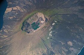
La Cumbre is a shield volcano on Fernandina Island in the Galápagos Islands.
Map of Volcan La Cumbre, Ecuador
La Cumbre began erupting again in April 2009. Lava flowing into the ocean could disrupt and destroy unique flora and fauna of the area. La Cumbre is the most active volcano of the Galapagos Islands, and is a high occupancy volcano. It is a volcano with a height of 1,476 m (4,842 feet). It has experienced several collapses of the caldera floor, often following explosive eruptions.
References
La Cumbre (Galápagos Islands) Wikipedia(Text) CC BY-SA