
Airport type Private Elevation 896 m | Elevation AMSL 2,940 ft / 896 m Phone +1 520-297-8096 | |
 | ||
Owner La Cholla Airpark, Inc. Website www.LaChollaAirpark.com Address 1777 W Cessna Way, Oro Valley, AZ 85755, USA Similar Dove Mountain Propertie, Brenda O'Brien - ABR - CR, Omni Tucson National, Oro Valley Real Estate Ian Taylor, Preserve at Dove Mountain | ||
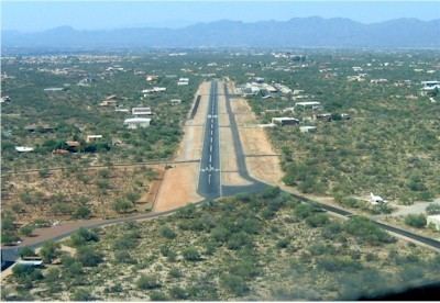
La Cholla Airpark (FAA LID: 57AZ) is a private airpark located in Oro Valley, Pima County, Arizona, eight miles (13 km) northwest of the central business district of Tucson. La Cholla Airpark was founded in 1972 and includes 122 homes and buildable lots in the foothills of the Tortolita Mountains. A 4,500 foot air strip is situated at the center of the community.
Contents
Transient aircraft are permitted to utilize La Cholla Airpark and prior permission is required. Insurance and flight information must be forwarded (fax) to the airpark prior to arrival. La Cholla Airpark supports a website to serve both the airpark homeowners and transient aircraft.
La cholla airpark
Facilities and aircraft
La Cholla Airpark has one asphalt paved runway (1/19) measuring 4,500 x 44 ft. (1,372 x 13 m). It also has one helipad measuring 44 x 44 ft. (13 x 13 m).
For the 12-month period ending December 31, 1999, the airport had 4,000 aircraft operations, an average of 10 per day, all of which were general aviation. As of January 15, 2009, 95 aircraft based at this airport: 95% single engine, 3% multi-engine and 2% helicopters.