
Traversed by foot Range Pyrenees | Elevation 2,804 m | |
 | ||
Location Hautes-Pyrénées, France
Aragón, Spain Similar Pic du Taillon, Cirque de Gavarnie, Monte Perdido, Pic de Marboré, Ordesa y Monte Perdido | ||
Randonn e la br che de roland et au pic du taillon cirque de gavarnie
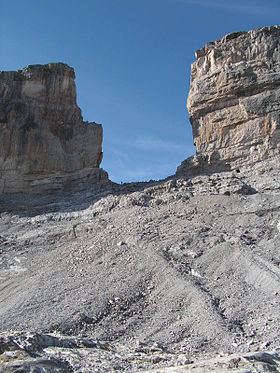
Roland's Breach (French: La Brèche de Roland; Spanish: La Brecha de Rolando; Aragonese: La Breca de Roldán; Basque: Errolanen Arraila; Catalan: La Bretxa de Rotllà; German: Rolandsbresche) is the name of a natural gap, 40 m across and 100 m high, at an elevation of 2804 m in the Pyrenees on the border of Aragón, northern Spain, and Hautes-Pyrénées, France.
Contents
- Randonn e la br che de roland et au pic du taillon cirque de gavarnie
- Map of La BrC3A8che de Roland 22375 Gavarnie France
- Randonn e la br che de roland video hd
- References
Map of La Br%C3%A8che de Roland, 22375 Gavarnie, France
The gap is situated in the Ordesa y Monte Perdido National Park on the Franco-Spanish border, close to the steep cliffs of the Cirque de Gavarnie.
According to legend Roland's Breach was cut by Count Roland with his sword Durendal in an attempt to destroy that sword, after being defeated during the Battle of Roncesvalles in 778.
The gap can be reached from the Refugio Sarradets, a nearby mountain shelter, in about an hour's climb.