
Canton Mirepoix Area 4.77 km² | Region Occitanie Intercommunality CC du Pays de Mirepoix Local time Friday 12:40 AM | |
 | ||
Weather 11°C, Wind W at 8 km/h, 62% Humidity | ||
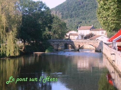
La Bastide-sur-l'Hers is a French commune in the Ariège department in the Occitanie region of southwestern France.
Contents
- Map of 09600 La Bastide sur lHers France
- Geography
- Mapping
- Toponymy
- Administration
- Demography
- Sites and Monuments
- Notable people linked to the commune
- References
Map of 09600 La Bastide-sur-l'Hers, France
The inhabitants of the commune are known as Bastidhersois or Bastidhersoises.
Geography
La Bastide-sur-l'Hers is located some 28 km south-east of Pamiers and 3 km north-east of Lavelanet. Access to the commune is by the D620 road from Laroque-d'Olmes in the north-west which goes east through the commune and the village and continues east to Le Peyrat. The D16 comes from L'Aiguillon in the south and passes north inside the eastern border of the commune to the village then continues north to join the D28A south of Léran. A former railway line now a walking trail passes through the commune from west to east just north of the village. The commune has two large belts of forest across the centre and south with most of the rest of the commune farmland.
The Hers river flows from the south forming the south-eastern border before passing through the village and continuing east to eventually join the Ariège at Cintegabelle. The Ruiseeau des Écrevisses forms the southern border of the commune as it flows east to join the Hers. The Ruisseau de Pépoulant also flows east across the commune a little further north and joins the Hers.
Mapping
A list of online mapping systems can be displayed by clicking on the coordinates (latitude and longitude) in the top right hand corner of this article.
Toponymy
La Bastide-sur-l'Hers appears as la Baftide de Cougoust on the 1750 Cassini Map and as la Bastide on the 1790 version.
Administration
List of Successive Mayors
(Not all data is known)
Demography
In 2010 the commune had 724 inhabitants. The evolution of the number of inhabitants is known from the population censuses conducted in the commune since 1793. From the 21st century, a census of communes with fewer than 10,000 inhabitants is held every five years, unlike larger communes that have a sample survey every year.
Sources : Ldh/EHESS/Cassini until 1962, INSEE database from 1968 (population without double counting and municipal population from 2006)
Sites and Monuments
There is a Monumental Painting (18th century) in a house which is registered as an historical object but its location is unclear.