Samiksha Jaiswal (Editor)

Hers Vif

Updated on
Edit
Like
Comment
Share on FacebookTweet on TwitterShare on LinkedInShare on Reddit
Country
  
France

Basin size
  
1,350 km (520 sq mi)

Discharge
  
15 m³/s

Source elevation
  
1,500 m

Mouth
  
Ariège

River mouth
  
Ariège

Length
  
135 km

Basin area
  
1,350 km²

Source
  
Pyrenees

Hers-Vif httpsuploadwikimediaorgwikipediacommonsthu

Main source
  
Pyrenees ±1,500 m (4,900 ft)

Progression
  
Ariège→ Garonne→ Atlantic Ocean

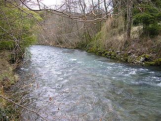
The Hers-Vif ("Live Hers", as opposed to the slower flowing Hers-Mort, "Dead Hers"), also named Grand Hers or simply Hers, is a 135-kilometre (84 mi) long river in southern France, right tributary of the Ariège.

The Hers-Vif rises at an elevation of about 1,500 metres (4,900 ft) near the Chioula Pass of the Pyrenees, approximately 6 kilometres (4 mi) north of Ax-les-Thermes. It is the major tributary of the Ariège into whose right bank it flows 2 kilometres (1.2 mi) upstream from Cintegabelle in the Haute-Garonne.

It flows some 30 kilometres (19 mi) through the Pyrenees, descending 1,100 metres (3,600 ft) to the village of Peyrat, where it reaches a piedmont plain. Its valley widens as it traverses the plain, reaching the medieval city of Mirepoix, which marks the start of its lower valley.

Several rivers flow into it:

  • From the Pyrenees: the Lasset; the Fontaine de Fontestorbes; the Touyre
  • From the piedmont plain and hills: the Blau and the Douctouyre;
  • From the hills of Lauragais and Razès: the Ambronne and the Vixiège.
  • Departments and towns along its course are:

  • Ariège: Prades, Bélesta, La Bastide-sur-l'Hers, Mirepoix, Mazères
  • Aude: Comus, Chalabre
  • Haute-Garonne: Calmont
  • Floods

    The Hers is probably known as vif (intense or rapid in this context) because of its sometimes spectacular floods – that of 16 June 1289 having entirely destroyed Mirepoix. More recently, there have been:

  • 23 June 1875: estimated flow rate of 1,500 cubic metres per second (53,000 cu ft/s) at Mazères;
  • 6 February 1919: estimated flow rate of 600 to 800 cubic metres per second (21,000 to 28,000 cu ft/s) at Mazères;
  • 19 May 1977: estimated flow rate of 1,070 cubic metres per second (38,000 cu ft/s) at Mazères;
  • 16 January 1981: estimated flow rate of 1,100 cubic metres per second (39,000 cu ft/s) at Mazères;
  • 11 June 2000: estimated flow rate of 500 cubic metres per second (18,000 cu ft/s) at Mazères;
  • 24 January 2004: estimated flow rate of 500 cubic metres per second (18,000 cu ft/s) at Mazères.
  • References

    Hers-Vif Wikipedia


    Similar Topics