
Population (2010) 820 Area 44.16 km² | Region Occitanie Time zone CET (UTC+1) Local time Friday 12:40 AM | |
 | ||
Weather 3°C, Wind E at 3 km/h, 91% Humidity | ||
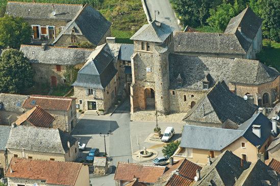
La Bastide-l'Évêque is a former commune in the Aveyron department in the Occitanie region of southern France. On 1 January 2016, it was merged into the new commune of Le Bas-Ségala.
Contents
- Map of 12200 La Bastide lC389vC3AAque France
- Geography
- Mapping
- Toponymy
- History
- Administration
- Demography
- Economy
- Civil heritage
- Religious heritage
- Notable people linked to the commune
- References
Map of 12200 La Bastide-l'%C3%89v%C3%AAque, France
The inhabitants of the commune are known as Episcopois or Episcopoises.
Geography
La Bastide-l'Évêque is located some 5 km east of Villefranche-de-Rouergue and 20 km south by south-west of Decazeville. Access to the commune is by the D911 which comes from Villefranche-de-Rouergue passing along the south-western border of the commune and crossing the narrow neck in the south as it goes east to Rieupeyroux. Access to the village is by the D69 which branches from the D911 on the western commune border and passes through the village continuing east to rejoin the D911 on the eastern border. The D269 goes north from the village then turns west following the northern border and continuing to Villefranche-de-Rouergue. The D905A branches from the D911 in the south of the commune and goes south-east to La Salvetat-Peyralès. Apart from the village the commune has a large number of hamlets:
The commune is mostly farmland interspersed with a few forests.
The Aveyron river forms most of the northern border as it flows west to eventually join the Tarn at Meauzac. The Lézert flows north through the commune to join the Aveyron on the northern border. The Verlanson also flows north joining the Lézert south of the village. The Ruisseau de Pouzoulet rises near Les Gazanes and also flows north to join the Aveyron. The Ruisseau de Caral rises in the east of the commune and flows north to join the Aveyron.
Mapping
A list of online mapping systems can be displayed by clicking on the coordinates (latitude and longitude) in the top right hand corner of this article.
Toponymy
La Bastide-l'Évêque appears as la Baftide l'Evesque on the 1750 Cassini Map and does not appear at all on the 1790 version although the hamlet of Cadour does.
History
Founded in 1280 by Bishop Raymond de Calmont, La Bastide l'Évêque is one of the five Bastides in western Rouergue with Najac, Sauveterre-de-Rouergue, Villeneuve d'Aveyron, and Villefranche-de-Rouergue. This was the foundation of the Diocese of Rodez on the remains of Morlhon and Faidits to counter the county bastide of Villafranca (Villefranche-de-Rouergue) to limit its population, influence, and development. The bishop granted a charter in 1280 but politically it was a failure and remained a fortified village.
In the 14th century mining was very important with 13 mills called "martinets" operating in the Lézert Valley. They were used to smelt copper and make cauldrons. This activity continued until the end of the 19th century then died for lack of profitability.
Administration
List of Successive Mayors
(Not all data is known)
Demography
In 2010 the commune had 820 inhabitants. The evolution of the number of inhabitants is known from the population censuses conducted in the commune since 1793. From the 21st century, a census of communes with fewer than 10,000 inhabitants is held every five years, unlike larger communes that have a sample survey every year.
Sources : Ldh/EHESS/Cassini until 1962, INSEE database from 1968 (population without double counting and municipal population from 2006)
Economy
The commune is mostly rural with many farms whose business ranges from cattle breeding but mostly sheep. Many tradesmen reside or work in the commune. Some people have chosen to settle in the commune but their occupation is in neighbouring towns like Villefranche-de-Rouergue or Rieupeyroux.