
 | ||
The LANDFIRE Program (“Landscape Fire and Resource Management Planning Tools") produces geo-spatial products and databases covering the United States of America. LANDFIRE is a partnership between the United States Department of Interior, the United States Forest Service and the Nature Conservancy that began officially in 2001. The purpose of LANDFIRE is to create a nationally complete, comprehensive, and consistent set of products that support fire and natural resource management organizations and applications.
Contents
LANDFIRE spatial products were designed for use at very large landscape, state, regional or national scales. LANDFIRE Program products have been used in a variety of ways, from supporting large federal wildland fire-related applications such as the Wildland Fire Decision Support System, and the Cohesive Strategy initiative, to landscape-level conservation planning, regional wildlife studies, ecosystem services, biofuels, and national carbon stock and biomass assessments. The LANDFIRE Program and the Nature Conservancy’s Conservation Gateway and Web-Hosted Applications Map websites list and describe a variety of applications of LANDFIRE products.
Products
LANDFIRE has three primary areas of work: digital spatial data, quantitative vegetation dynamics models and a small number of user tools.
Spatial Data
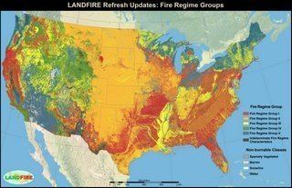
The LANDFIRE Program product set includes a suite of more than 20, 30-meter spatial resolution raster data sets that cover the entire nation, regardless of ownership. A subset of LANDFIRE products is available for U.S. insular areas. The data sets are created using a consistent set of processes and inputs, they are fully compatible with each other, and they are ready to use immediately after being downloaded. All layers are freely available for download from the LANDFIRE Program website and are delivered map zone by map zone, as continuous national mosaics, or as Web Service Calls in Arc GRID format. The layer suite includes existing vegetation type, cover and height, potential vegetation (Environmental Site Potential), pre-European settlement vegetation (Biophysical Setting), fire regime group, fire behavior fuel models, fire effects, natural and human-caused disturbance, vegetation transition rules, and others. See the "Versions and Update Schedule" section below for information on time periods covered by the product suite.
Ecological Models
The LANDFIRE Program has developed a series of quantitative vegetation dynamics models, which are also free and available from the program website. LANDFIRE vegetation dynamics models quantitatively describe the pre-European settlement succession and disturbance pathways for each major Ecological System in the U.S. A detailed description of the Ecological System is also provided. The descriptions are available as PDF files; the ecological models are delivered as a Microsoft Access database to be used with SyncroSim and with the Vegetation Dynamics Development Tool. These models and descriptions are used in the Landscape Conservation Forecasting process, Forest Scenario Modeling and other on-the-ground decision-making efforts.
Tools
LANDFIRE and partners created a number of tools aimed at helping users utilize LANDFIRE and other spatial data sets. The LANDFIRE Total Fuels Change Tool allows users to review how Fire Behavior Fuel Models are derived. The LANDFIRE Program also provided a LANDFIRE Data Access Tool (LFDAT) which allows users to download and process LANDFIRE spatial data directly from ArcMap. More information on tools can be found on the LANDFIRE Program website.
Versions and update schedule
The LANDFIRE program currently has delivered five data versions representing four distinct time periods available for public download on the program website. LF1.0.5 provides data circa 2001. Updates from 2001-2008 were identified and incorporated into LF1.0.5 to create LF1.1.0 representing conditions in 2008. Landscape changes from 2008 – 2010 were mapped and incorporated to create LF1.2.0 (2010). Most recently, the LANDFIRE Program delivered another updated data set (1.3.0) to represent landscape conditions in 2012. These four versions may be downloaded from the program website interactively, or as a national mosaic (CONUS only). The original LANDFIRE version (LF1.0.0) is available by special request. LANDFIRE is currently working on a circa 2014 data set (LF1.4.0) to be delivered in late CY2016, and is planning a remap of relevant vegetation layers following completion of LF1.4.0.
Review and Update
The LANDFIRE Program encourages and welcomes feedback on any product of the program at any time from any organization or individual. Formal review requests are distributed occasionally. For example, in 2016 The Nature Conservancy’s LANDFIRE Team conducted a formal, program-wide review of Biophysical Settings (BpS) Models and Descriptions, and the LANDFIRE Program has created a web environment that allows users to provide direct feedback on Fire Behavior Fuel Model products. To be included in this review process, or receive an invitation to formally participate in any LANDFIRE review activities, send request via LANDFIRE website contact page. Though the first deadline for BpS review passed, the site remains open and reviews will continue to be accepted via BioPhysical Settings Review.