Supriya Ghosh (Editor)

Ländchen (Havelland)

Updated on
Edit
Like
Comment
Share on FacebookTweet on TwitterShare on LinkedInShare on Reddit
Ländchen (Havelland)

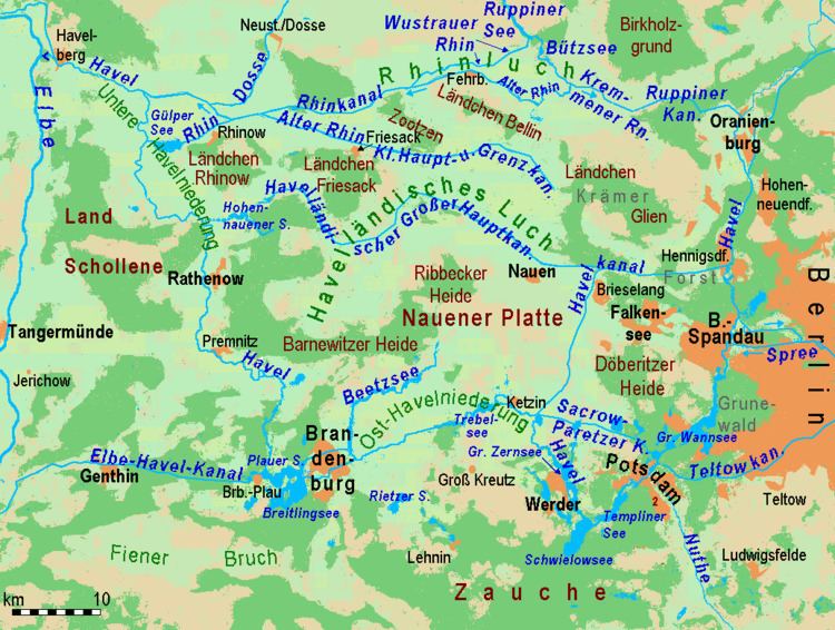
A Ländchen is the German name given to several Ice Age plateaux in the Havelland region, which climb to over 70 metres above the formerly marshy urstromtal levels (old glacial meltwater valleys) of the Havelland Luch and the Rhinluch. The difference between these Ländchen and the surrounding countryside is even more marked because of the different land uses to which they are put. Extensive pastures in the lowlands contrast with the arable fields and woods on the low hills. Geologically they are largely complete formations of ground moraine from the Saale and Weichselian glaciations that, in places, are covered by gently rolling end moraines.

Their names are:

  • Ländchen Bellin near Fehrbellin (52.78°N 12.79°E / 52.78; 12.79 (Ländchen Bellin))
  • Ländchen Friesack near Friesack (52.70°N 12.56°E / 52.70; 12.56 (Ländchen Friesack))
  • Ländchen Glien near Paaren im Glien north of Falkensee (52.68°N 13.05°E / 52.68; 13.05 (Ländchen Glien))
  • Ländchen Rhinow near Rhinow near the confluence of the Rhin and the Havel (52.72°N 12.35°E / 52.72; 12.35 (Ländchen Rhinow))
  • Land Schollene between Havel and the Elbe valley, west of Rathenow (52.63°N 12.16°E / 52.63; 12.16 (Land Schollene))
  • Ribbeck Heath, part of the Nauen Plateau (52.60°N 12.73°E / 52.60; 12.73 (Ribbeck Heath))
  • Zootzen north of Friesack, scarcely higher than the Luche (52.76°N 12.67°E / 52.76; 12.67 (Zootzen))
  • References

    Ländchen (Havelland) Wikipedia